 Route Editor

| Guide | ♦ | 11 Triplogs | 0 Topics |
details | drive | no permit | forecast | 🔥 route |
stats |
photos | triplogs | topics | location |
| 148 | 11 | 0 |
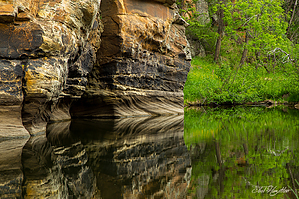
Cliffs and Crawdads by JoelHazelton   Overview OverviewAn off-trail hike following fishermen routes, game trails, and a perennial creek from the Forest Road 95 crossing of East Clear Creek to the junction with Kinder Crossing Trail #19. Warning This route is seldom traveled and requires bushwhacking, deep wading, and one mandatory swim. If you intend to backpack this route, you will need a method of dry-proofing your gear. All water along this route must be filtered before drinking.
This hike is best done as a shuttle, but a loop is possible with about 3 miles of road hiking along FR95T and FR95. Begin the hike at the large parking area south of the FR95 crossing at East Clear Creek. The descent into the creek from the parking area is steep and short. From here, it is a matter of following fishermen's routes and game trails downstream. Follow the path of least resistance, or if it is an exceptionally warm day, stay in the creek, as it rarely exceeds waist-deep. Hikers will likely encounter day-trippers and anglers for the first 1/4 mile. The crowds quickly thin out, and hikers will soon have the entire creek to themselves. At just over the 1-mile mark, there is a short section of boulders, requiring some careful rock hopping and some possible class 3 navigation, depending on the exact route. Once this section is completed, it is not long until the first and only mandatory swim at approximately 1.35 miles. This swim is approximately 50 feet long, and it is not possible to keep gear dry through this section of the creek without some waterproofing method. I used a $5 raft from Target to float our overnight packs across, one at a time, and except for some wet straps hanging into the water, everything survived just fine. After completing this swim, I was able to eyeball a potential sketchy route up and over some cliffs on the west side of the creek that could have potentially avoided the swim. Still, it looks downright dangerous at spots, and even if this route is possible, it is not recommended, especially for those carrying heavy overnight packs. After this mandatory swim, the route immediately becomes less defined. Heavy bushwhacking is more common, and signs of wildlife, especially elk, become more apparent. This begins an incredibly beautiful, remote, and wild section of the creek, with canyon walls soaring over an abundance of idyllic swimming holes. We hiked this route on an ~85-degree day and took multiple opportunities to drop our packs and take dips in the pools. A perfect, flat, sandy campsite is encountered at almost exactly the 2-mile mark, at a hard bend left in the creek (heading downstream). Many other flat spots for camping are passed along this hike, but most are full of small rocks, making for less comfortable nights of sleep (speaking from experience). Within a mile of Kinder Crossing (around the 4-mile mark), trails and other signs of visitation become more common. Soon the trail crosses to the north side of the creek and promptly climbs up to a forested bench with a perfect campsite. Quickly after this, campsite hikers will pass a trail sign, marking the lower end of the Kinder Crossing Trail, approximately 4.5 miles downstream from the FR95 crossing. From here, hikers can either hike up Kinder Crossing Trail or continue farther downstream another ~2.5 miles and exit at the Horse Crossing Trail. Please reference Kinder Crossing Trail #19 or Horse Crossing Trail #20 for details on these exit routes. While the Kinder and Horse Crossing sections of East Clear Creek offer more forested benches for camping and easier access, it is my opinion that the harsher topography and inaccessibility of the FR95 to Kinder stretch make it more serene and beautiful. Having done this stretch, Kinder Crossing, Horse Crossing, and Macks Crossing, I find the section outlined in this hike description to be the most beautiful section of East Clear Creek that I have seen. Check out the Official Route and Triplogs. Leave No Trace and +Add a Triplog after your hike to support this local community. One-Way Notice This hike is listed as One-Way. When hiking several trails on a single "hike", log it with a generic name that describes the hike. Then link the trails traveled, check out the example. | |||||||||||||||||||||||||||||||||||||||||||||||||||||||||||||||||||||||||||||||||||||||||||||||||||||||||||||||||||||||||||||||||||||||||||||||||||||||||||||||||||||||||||||||||||||||||||||||||||||||


