username
X
password
register
for free!
help


Crystal Cove State Park, CA

Guide 9 Triplogs  0 Topics
  0 of 5  
Fav
Wish
0
details
drive
permit
forecast
map
stats
photos
triplogs
topics
location
80 9 0
Statistics
tap row or icons for details
Difficulty 2 of 5
Route Finding 1 of 5
Distance Multi-Loop 5.75 miles
Trailhead Elevation 46 feet
Elevation Gain 750 feet
Avg Time Round Trip 2.25 hours
Kokopelli Seeds 9.5
 Interest Historic & Seasonal Creek
 Backpack Yes
 Dogs not allowed
feature photo
Photos Viewed All MineFollowing
18  2025-08-22 PatrickL
13  2015-06-03 ddgrunning
7  2015-05-14 burntlizard
9  2014-03-29
Crystal Cove State Park
Stoic
3  2009-04-08 AZHikr4444
30  2009-04-05 chumley
Author
author avatar Guides 94
Routes 840
Photos 22,055
Trips 1,993 map ( 15,547 miles )
Age 52 Male Gender
Location Tempe, AZ
Associated Areas
list map done
Orange Region
Historical Weather
Trailhead Forecast
Expand Map
Preferred Dec, Jan, Feb, Mar → 8 AM
Seasons   ALL
Sun  5:27am - 6:13pm
1 Route
 
1 Alternative


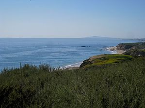
Ocean breezes and sights worth seaing
by chumley

 
The Laguna Coast Wilderness portion of Crystal Cove State Park is 2,400 acres of native backcountry traversing the picturesque San Joaquin Hills of Southern California, about a mile north of Laguna Beach.


The land for the park was purchased by the State in 1979, preserving what had been cattle grazing land and part of the Irvine Ranch since 1864.
remove free decal offer
Upon establishment of the park, the ranch roads were closed to vehicular traffic, but are now utilized as multi-use recreational trails. There are 17 miles of trails in the park, mostly consisting of these old roads, but there's also some single-track.

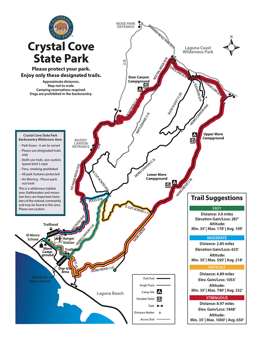
Three parallel trails lead north from the Pacific. The El Moro Canyon trail follows the seasonal El Moro Creek up the canyon and presents the hiker with a gentle upward climb through coastal sage scrub, with some occasional riparian shade provided by oak and sycamore trees.

On the ridges on either side of El Moro Canyon are parallel trails which feature more exposure and subsequently, better views; the San Joaquin Hills, the Pacific Ocean, Catalina Island, and the coastal cities of Laguna Beach and Newport Beach. When you're in the canyon, it's easy to forget that you're in such a densely populated part of southern California, but on the ridges, the distant views serve as a reminder.

Several trails connect the ridge trails with the canyon trail, and provide a bit more of a workout as the ridges rise to over 900 feet above sea level. The connecting trails are steep, but the rewards are great.

There are three primitive campgrounds which can be reserved, and are only accessible by hiking, resulting in a reasonable 3 mile backpack/camping possibility. This area is popular for hiking and mountain biking, but since most of the trails are old roads, there's plenty of room for the shared uses.

There's a visitor center at the trailhead which features maps and a park ranger who can direct you on the most appropriate route through the park for your skill level and time constraints, including separate loop hikes of about 3, 5, or 11 miles.

2009-04-07 chumley
  • guide related image
    guide related


Check out the Triplogs.
Leave No Trace and +Add a Triplog after your hike to support this local community.
WARNING! Hiking and outdoor related sports can be dangerous. Be responsible and prepare for the trip. Study the area you are entering and plan accordingly. Dress for the current and unexpected weather changes. Take plenty of water. Never go alone. Make an itinerary with your plan(s), route(s), destination(s) and expected return time. Give your itinerary to trusted family and/or friends.

 Permit $$
CA State Parks - Fee: typically per vehicle, view more information


 Directions
or
 Road
Paved - Car Okay

To hike
The trailhead is located 2 miles south of Corona del Mar, and 1 mile north of Laguna Beach on the Pacific Coast Highway. El Moro Canyon Road has a traffic light, and leads into the parking lot and ranger station where restrooms and water is available.
page created by chumley on Apr 06 2009 10:28 pm
 90+° 8am - 6pm kills
helpcorrectionissue

end of page marker