 Route Editor

| Guide | ♦ | 11 Triplogs | 0 Topics |
details | drive | permit | forecast | 🔥 route |
stats |
photos | triplogs | topics | location |
| 283 | 11 | 0 |
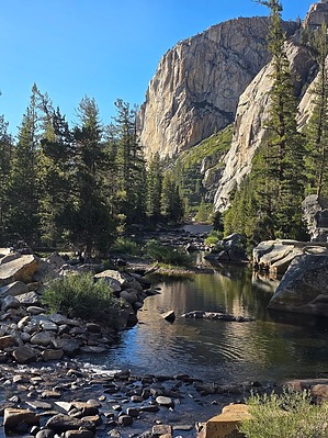
Who Needs Half Dome?? Backpack in beautiful Tuolumne! by Vashti This is black bear country! Store your food appropriately! Bear cannisters are required by Yosemite National Park, and there is an approved listing of cannister brands. Only approved brands are allowed on the trail. Note that bear spray is NOT ALLOWED in Yosemite NP. Overview An amazing backpack with amazing sites at every step!
If you start at White Wolf, day 1 is 3,500 feet down and approximately 11 miles to the first campsite areas. From the White Wolf campground and trailhead, the vegetation is lush and thick. The first mile or so is quite flat. After that, you rise ever so slightly on the way to the edge of the canyon. But after the 3rd mile, it's all over and the direct descent begins! There are a couple of trail junctions, but all are well signed. There is no water on this first day until you hit Morrison Creek at 7 miles and 2400 ft below the starting point at white wolf. Morrison Creek is an excellent spot for a break and a convenient place to filter water. From Morrison, it's only another 1400 ft to drop, but it's relentless! You can see the river in the canyon below, but it is still a ways down. There is quite a bit of sun exposure in this area as you leave the trees behind for a while. The bottom of the canyon is reached, and the trail ambles along to the right of the river. The last 2 miles are back in the trees, and it is a bit humid, warm, and buggy. I made use of the recommended face bug net. It really came in handy to keep the mosquitoes and bugs at bay! As you approach the 11-mile mark, the canyon gets wider in a meadow area surrounded by trees. There are many, many campsites in the area, on both sides of the river. We camped before the footbridge, but there were campers on the other side, as well. Water is easy to filter from the river, which also makes an excellent swimming hole. This is the warmest location at a low elevation of 4400ft. Day 2 begins with crossing the footbridge over the Tuolumne River. Whereas day 1 was spent on the south side of the river, day 2 was spent on the north side. The day is spent mostly in the canyon, but not always right next to the river. You can always see the river, but it's not always accessible for finding water. The elevation gain for the coming day is around 2700 ft, depending on where you decide to make camp. The RS Route created by @chumley on 7/22/2016 is invaluable, as all the campsites are listed. This is very helpful as most of the area is not flat/suitable for camping, and you are not allowed to create new campsites, only use existing ones. The scenery on this day is fantastic, with views along the river, from up high, and of many waterfalls. Just before the 5-mile mark, you reach a confluence at Rodgers Canyon and Muir Gorge. After crossing 2 rivers, you move away from the river and start uphill. Within another half mile, the switchbacks begin in earnest, which carry you up a rock butte. You pass a waterfall along the way, which was dry when we were there. Upon reaching the top, the views are fantastic! Take a moment to really enjoy the view before heading down and back next to the river. After arriving at the river, the area opens up to a wide, flat area appropriate for camping or a rest stop. The canyon remains open and relatively flat for the next 1.5 miles before narrowing up again by Cathedral Falls and continuing uphill. This last section before the day 2 camp goes through some heavy, lush vegetation and a spectacular forest area. Gigantic trees with enormous pinecones over a foot long! It's a couple more miles before the canyon opens wide again, where the river meanders along, offering, yet again, more superb views. There is a bridge to cross, and then we ended our second day camping in a great area just to the left of the trail past the bridge. This area is the confluence of Return Creek and the Tuolumne River. It is an easy place to access for filtering water and swimming, though at this higher elevation (6100ft), the water is much colder than the day before!! 🤣🤣 If this campsite is taken, there is a spur trail heading north and up that has additional campsites, as well as continuing further down the main trail. However, after a long day, we were super happy to camp at the confluence! Day 3 was a short day for us. It depends on which camping area you are assigned to on your permit. We went 3 miles with 1500 ft gain. The trail heads away from the confluence and up up up towards the big Water Wheel Falls at 1.3 miles. There is another considerable waterfall along the way, as well. Waterwheel is a beautiful area worth spending some time in. Just above Waterwheel is a great swimming area. The area opens up to a wide valley. In a half mile, you switchback up to the Conte Falls area. There is a short spur that leads to a Comte Falls lookout. The trail remains left of the river, and this area is beyond beautiful with many wonderful swimming areas (though the water is numbingly cold!). We chose to camp in a delightful area with trees near a waterfall and a large pool, right before the trail starts an ascent again. Given our short day, we set up Camp and took a day hike out to McGee Lake, which is not seen along the way to the trailhead where we would end our hike. Day 4 is 8 miles to the Tuoloume Meadows Trailhead area. The trail starts with an uphill rock step climb towards California Falls. Once past the falls, the Glen Aulin area is beautiful, flat, and wide open as the river meanders in the space. There are areas in dense trees as well as meadows. There are several large established camping areas, but depending on your permit, you may be unable to use them. We were not allowed to camp within 1 mile of the Glen Aulin High Sierra Camp. Our campsite for night 3 was fantastic; it just meant that day 3 was shorter and day 4 longer. From California Falls to the High Sierra Camp (HSC) is about 2 miles. There are some nice cascades just before heading into the High Sierra camp area. At the HSC, there are some trail junctions, one before the HSC and one shortly after, as well as a couple of bridges. One bridge takes you into the HSC, which was closed for its normal full-service operation due to renovations when we were there, but there was still permit-only, no-services camping allowed. Taking the bridge over to the HSC and to the right is a large waterfall with a large pool. A great place for a swim or a break. Otherwise, head back over the bridge leading out of the HSC and back onto the main trail with a bridge giving you a nice view of those same falls. The trail heads up a short incline (look left to take in the white cascades) to a trail junction. To the right is the trail that passes by the narrow McGee Lake, to the left is the trail to Tuoloume Meadows, which is just over 5 miles away. Heading left takes you uphill with a phenomenal view of white cascades and soon Tuolumne Falls. The incline continues along with more falls to the left. After crossing a double footbridge, the area levels out. You are in the forest for a while, but then the area really opens up wide and flat, and you cross flat, smooth rock areas littered with some rocks and boulders. The scenery is no less beautiful or expansive, but markedly different from previously. The landscape continues in this way, into and out of tree areas, until you start picking up quite a bit more foot traffic going in the opposite direction. Day hikers from the soda spring area, towards which you are heading. At about Mile 5, the trail heads a little further away from Tuoloume Creek. Upon reaching the Soda Springs area, there is a junction. You can continue straight east to one Trailhead parking area, or you can head south to the right, which brings you to a Trailhead nearer to the visitor center. The Soda Springs area is a neat area with a historical building (Parsons Memorial Lodge) and an unusual spring area. There are a number of interpretive signs explaining the history of the area. There were a number of people in this area, given its proximity to civilization. 😊 From here, the trail east is basically an old dirt road to the trailhead, so not much else to mention. Water Sources Lots of water along the way, except for day one. Water, while right next to you on the trail for a majority of the hike, is not always easily accessible. Camping Camping is governed by specific permit areas. Camping is only allowed in areas previously used for camping. Camping in new/virgin areas is not allowed. Approved bear cannisters are required. Synopsis This backpack is fantastic! Not to be missed!
Check out the Official Route and Triplogs. Leave No Trace and +Add a Triplog after your hike to support this local community. One-Way Notice This hike is listed as One-Way. When hiking several trails on a single "hike", log it with a generic name that describes the hike. Then link the trails traveled, check out the example. | ||||||||||||||||||||||||||||||||||||||||||||||||||||||||||||||||||||||||||||||||||||||||||||||||||||||||||||||||||||||||||||||||||||||||||||||||||||||||||||||||||||||||||||||||


