Route Editor

| Guide | ♦ | 2 Triplogs | 0 Topics |
details | drive | permit | forecast | route |
stats |
photos | triplogs | topics | location |
| 35 | 2 | 0 |
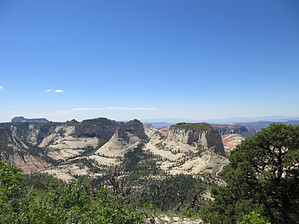
Best Views of Zion! by Jim  Fighting the likely crowds during full tourist season, hike up the West Rim Trail from the west side of Zion Canyon, leaving from the Grotto Trailhead and crossing the Virgin River via foot bridge. Ascend the paved trail up Walter's Wiggles, into Refrigerator Canyon, and approach Angel's Landing. From here, leave the crowds behind and proceed up to the north on the West Rim Trail. Views really open up once above the Angel's Landing split. You will hike over some exposed slick rock segments, and then drop down in to a pine filled drainage, crossing over a wash on a second foot bridge. Beyond this part, you continue to gain elevation as you climb steadily up and past the bright white cliffs of Navajo Sandstone that surround you on this slick rock shelf above Zion Canyon. Continue to climb on more trail which was cut into the white cliffs and has dramatic views of Zion Canyon below the Narrows.
This upper plateau area has been subjected to numerous stand replacing fires, and only scattered pines remain. What this area looked like 100 years ago is a distant memory, and today a chaparral of oak dominates what was probably a mixed forest of old growth orange bark ponderosa and scrub oak, over a grassy landscape. Elements of this remain in scattered stands of dense second growth pine with old growth trees, but several stand replacing fires have steadily burned off most of the old growth, leaving only scattered blacked skeletons with very limited young pine reproduction. However, though the forest is not what it historically would have been, the views from this section are spectacular. After several miles you will arrive at the northern junction for the Telephone Canyon Trail, just after encountering campsite # 6. From this point, you hike down into upper Telephone Canyon and south, back towards the point where you initially gained the plateau top. Views are lost as you rapidly lose elevation dropping into upper drainages which have maintained their forest cover. This is the shortest segment of trail and it goes quickly. Soon enough, you will meet up with the original section of the West Rim Trail under two very large old Ponderosa Pines. If you didn't do so when you reached this point on the way up, take a side trip to the spring, or relax under the large pines and enjoy the spectacular view of Zion Canyon. Thereafter, hike back down the trail to Angel's Landing, and out to the trailhead. If you choose to ascend Angel's Landing, plan for about an hour of additional hiking, and add in the appropriate miles and elevation gain to your trip log. This hike is going to be best in warmer months. It can be done most of the year, but snow can accumulate to depths on the plateau, so you may have difficulty attempting it in winter. Starting earlier in the morning and finishing in later afternoon, even in summer, will give you pretty warm but comfortable conditions to hike this. As always, beware of thunderstorms during summer, and stay out of exposed sections, which is most of the plateau, when lighting is nearby. I had a fantastic break day in mid-August, and a great day out on the trail.
Check out the Official Route and Triplogs. Leave No Trace and +Add a Triplog after your hike to support this local community. | ||||||||||||||||||||||||||||||||||||||||||||||||||||||||||||||||||||||||||||||||||||||||||||||||