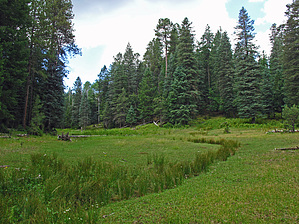
A scenic and peaceful loop hike, which includes numerous perennial(4) and seasonal named/unnamed springs. This moderate and mostly "off-trail" loop hike close to our Mogollon Rim- Cabin Loop area trails with route-finding skills recommended, offers a very pleasant remote hiking experience within the entire off-trail length of Maverick Canyon to intersect scenic, historic sections of Upper to the start of Middle Merritt Draw.
WARNING! Hiking and outdoor related sports can be dangerous. Be responsible and prepare for the trip. Study the area you are entering and plan accordingly. Dress for the current and unexpected weather changes. Take plenty of water. Never go alone. Make an itinerary with your plan(s), route(s), destination(s) and expected return time. Give your itinerary to trusted family and/or friends.
Permit $$
None
Directions
Road
High Clearance possible when dry
To Mid FR139C (arbitrary/unofficial) Trailhead From Phoenix
Drive Hwy 87 north through Payson, Pine, and Strawberry.. approx 10.5 miles north of Strawberry on Hwy 87 at MP281.1, turn right at signed FR300 (the Rim Road). From this intersection...
Utilize this GPS Driving Route "from" the intersection of Hwy 87/FR300 (Rim Road) at Hwy 87 Milepost 281.2 "to" the recommended FR139C TH Start at Camp Grasshopper-Campsite #3 (or #2). (Trailhead is generic)
page created by Grasshopper on Sep 01 2016 3:34 pm
 Route Editor

 A scenic and peaceful loop hike, which includes numerous perennial(4) and seasonal named/unnamed springs. This moderate and mostly "off-trail" loop hike close to our Mogollon Rim- Cabin Loop area trails with route-finding skills recommended, offers a very pleasant remote hiking experience within the entire off-trail length of Maverick Canyon to intersect scenic, historic sections of Upper to the start of Middle Merritt Draw.