 Route Editor

| Guide | ♦ | 13 Triplogs | 0 Topics |
details | drive | permit | forecast | route |
stats |
photos | triplogs | topics | location |
| 206 | 13 | 0 |
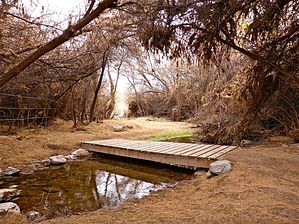
Gates'R'Us by kingsnake  The Agua Fria Trailhead is just north of the Carefree Highway (AZ-74), at the south end of Lake Pleasant. I’ve driven past the Beardsley CSR Road many times. I always thought it was “official use only”, but at least as far as the trailhead, it is open to the public. There is no park entrance fee for parking there. (Unlike if you park at the north end of Beardsley Trail on Desert Tortoise Rd.) The Agua Fria Trailhead is just north of the Carefree Highway (AZ-74), at the south end of Lake Pleasant. I’ve driven past the Beardsley CSR Road many times. I always thought it was “official use only”, but at least as far as the trailhead, it is open to the public. There is no park entrance fee for parking there. (Unlike if you park at the north end of Beardsley Trail on Desert Tortoise Rd.)The first of six gates, a ‘V gate’, is at the trailhead. (The rest are all some variety of swinging gates.) After passing through the gate, Beardsley Trail descends to Morgan Wash on the Agua Fria River. Morgan Wash is filled with typical Arizona river bottom brush, but there is no threat of impromptu acupuncture, as Beardsley Trail is well cleared. That remains true to Desert Tortoise Rd. The temperature is noticeably cooler in Morgan Wash, which is crossed by two wooden footbridges. (With a second gate in between.) On the west side of Morgan Wash, the Maricopa Trail — which is initially co-located with the Beardsley Trail — turns south while Beardsley turns north.
After crossing Old Lake Pleasant Rd., Beardsley Trail is never more than a ¼ mile from pavement. The sound of heavy Carefree Highway traffic begins fading, being replaced by regular aircraft flybys. Beardsley Trail generally follows the contour line from spurs & washes running west off Lake Pleasant. Heading north, it is uphill (550 AEG), with two 170 ft. climbs. Heading back south to the Agua Fria Trailhead, Beardsley is generally downhill (300 AEG). The trail surface is not pristine, but it is still mostly rock-free. Beardsley would be excellent for trail running or as a fast mountain bike track. At 2.2 miles, Beardsley Trail crosses the fifth gate, then intersects Frog Tanks Trail, which runs 0.3 miles northeast to the Bobcat Day Use Area. From the fifth gate, it is 2.1 miles, a sixth gate, and a final road crossing, to Beardsley’s northern terminus on Desert Tortoise Rd. Beardsley Trail is good exercise on a great trail, but nothing special without scenery, flowers, or critters. But it does have far fewer people than Phoenix Mountains Preserve, so there is that. Gate Policy: If a gate is closed upon arrival, leave it closed after you go through. If it is open, leave it open. Leaving a closed gate open may put cattle in danger. Closing an open gate may cut them off from water. Please be respectful, leave gates as found. The exception is signage on the gate directing you otherwise.
Check out the Official Route and Triplogs. Leave No Trace and +Add a Triplog after your hike to support this local community. One-Way Notice This hike is listed as One-Way. When hiking several trails on a single "hike", log it with a generic name that describes the hike. Then link the trails traveled, check out the example. | ||||||||||||||||||||||||||||||||||||||||||||||||||||||||||||||||||||||||||||||||||||||||||||||||||||||||||||||||||||||||||||||||||||||||||||||||||||||||||||||||||||||||||||


