 Route Editor

| Guide | ♦ | 3 Triplogs | 0 Topics |
details | drive | permit | forecast | route |
stats |
photos | triplogs | topics | location |
| 18 | 3 | 0 |
 The first mile of the trail follows a wide, exposed logging road through a thicket of white leaf manzanita, knobcone pine, redbud, wild grape and poison oak. Near the creek this brushland transitions into a forest of ponderosa pine, Douglas fir, and canyon live oak. Look for ladybugs in a clearing just before the first creek crossing. Thousands have been seen next to the side of the trail on sunny days in fall, winter and early spring.
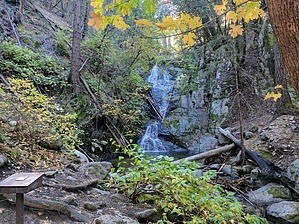
Approaching the falls, the trail drops down into a cool watershed. The creek leading from the falls is visible, crossing the road. The sign for the short side trail to the falls will be on your left. Follow the steps up the hill to a rocky vantage point where the main falls can be seen. The falls directly ahead are 81 feet tall with an additonal 28 feet of cataracts above. Plants that flourish in this riparian habitat are tiger lily, solomon seal and chain fern. The trail continues on to Mill Creek Road. Turn right and walk to Carr Powerhouse, 1.7 miles distant. Or, return the way you came Warning Watch for poison oak, and be careful crossing slippery boulders. History Boulder Creek cuts through Copley greenstone, a Devonian metamorphic rock of near- shore oceanic origin formed about 400 million years ago. It ranges in color from dull orange and light brown (weathered) to dark blue-green. Along the trail and in the creek bed you will see numerous areas where the greenstone is capped with granitic boulders. These are debris flows from the Shasta Bally batholith (Cretaceous, 133 million years) that from time to time have washed down the mountain into the creek valley. Several hundred yards above the falls, a particularly good example of this formation may be seen. Across Mill Creek Road at the upper trailhead is a majestic ravine that follows the Hoadley fault through much of the park. The Hoadley is an inactive extensional fault, slightly older than the Shasta Bally Batholith.
Check out the Official Route and Triplogs. Leave No Trace and +Add a Triplog after your hike to support this local community. One-Way Notice This hike is listed as One-Way. When hiking several trails on a single "hike", log it with a generic name that describes the hike. Then link the trails traveled, check out the example. | ||||||||||||||||||||||||||||||||||||||||||||||||||||||||||||||||||||||||||||||||


