|
tap row or icons for details
|
| Difficulty |
|
2 of 5 |
| Distance Loop |
|
1.3 miles |
| Trailhead Elevation |
|
800 feet |
| Accumulated Gain |
|
500 feet |
| Avg Time Round Trip |
|
45 mins |
| Kokopelli Seeds |
|
3.8 |
| Interest Peak | | Backpack No | |
| | |
|
|
3 |
2016-08-25 | uphill_junkie |
|
| |
|
|
|
list |
map |
done |
Southern Region |
| | |
|
| |
|
|
Historical Weather |
| Trailhead Forecast | | |
|
 |
|
|
| Preferred Sep, May, Jun, Aug |
| |
|
|
| | |
| |
Named Locations Coordinate Links
| |
|
| help future hikers |
| post a gps route now |
| | |
| |
|
|
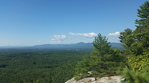
 This hill is in the town of Lovell, and is one of the small peaks with a nice loop trail to get some exercise. It is very popular with the locals and visitors alike. It is almost completely under canopy with only a small section along the ridge of the top, and the peak itself being exposed. There are 2 benches and lookout areas at the top with a pretty nice view of Lake Kezar and the surrounding area. Almost all trees and green with a few houses scattered about here and there that you can see through the mesh of trees. It can get crowded on weekends with visiting families, and you'll almost always find someone else on the trail somewhere along the loop, unless you know the right times to go and have it to yourself. When it rains, and when it's humid is your best bet. The most popular way of doing the loop is going counter-clockwise, as the trail is a little more gradual on the incline. Tugger and I almost always go clockwise, as it seems like more of a push.
A great little gem for some quick exercise. |
 Route Editor