Route Editor

| Guide | ♦ | 35 Triplogs | 2 Topics |
details | drive | no permit | forecast | 🔥 route |
stats |
photos | triplogs | topics | location |
| 360 | 35 | 2 |
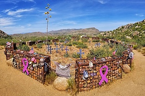
honor the sacrifice by HAZ_Hikebot   Overview Overview2.85 mi Hotshots Trail 0.75 mi Journey Trail  Hike From the trailhead, the Hotshots Trail is a 2.85-mile path up to the Observation Deck. Every 600 feet, 19 granite plaques set into rocks share a photo and a story of each fallen Hotshot. Additional interpretive signage provides information about wildland firefighting.
The 3/4-mile Journey Trails allows you to follow the last steps of the Hotshots down to the Fatality Site where they made their last stand. Encircling the Fatality Site, 19 gabions, one for each Hotshot, are united by chains representing their eternal team. A path surrounds the gabions and a memorial flagpole. Please, take a moment to pay your respects, but remain outside of the gabion enclosure out of respect for the Hotshots and their families. Note The trail is 7.2 miles round-trip, please dress appropriately, bring adequate water, food, and plan for a four-hour-plus round-trip hike. There is no access to drinking water along the trail. Those making the seven-mile hike should begin before noon and carry a flashlight in the event hiking out after dark becomes necessary. The hike back to the trailhead will take about 2 hours. Please plan accordingly. Please pack in & pack out any trash. Leashed dogs are welcome on the trail and owners must pick up after them.
Check out the Official Route and Triplogs. Leave No Trace and +Add a Triplog after your hike to support this local community. | ||||||||||||||||||||||||||||||||||||||||||||||||||||||||||||||||||||||||||||||