Route Editor

| Guide | ♦ | 15 Triplogs | 1 Topic |
details | drive | no permit | forecast | route |
stats |
photos | triplogs | topic | location |
| 103 | 15 | 1 |
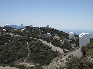
Why drive when you can hike? by Davis2001r6  If you've driven west on AZ-86 out of Tucson, you've probably seen Kitt Peak off the side with all the observatories on top. The peak falls on the Tohono O'odham Nation grounds. There is a road you can drive up Kitt, but why drive when you can hike. There an old Jeep road that you can take that will get you to the top as well. It's marked for Emergency use only, so don't plan on driving it or seeing other people along the way. If you've driven west on AZ-86 out of Tucson, you've probably seen Kitt Peak off the side with all the observatories on top. The peak falls on the Tohono O'odham Nation grounds. There is a road you can drive up Kitt, but why drive when you can hike. There an old Jeep road that you can take that will get you to the top as well. It's marked for Emergency use only, so don't plan on driving it or seeing other people along the way.The road is clear from the parking area and has a nice steady grade on the way up. The average grade is 13%, so it's enough to get your heart beating, not to make you want to turn around. There is plenty of cactus and nice views along the way. To the South, you have a great view of Baboquivari Peak.
Once near the top, you'll hit the main road. Just head a couple hundred yards up and another short scramble, and you'll be on top. The hike was shielded nicely from the wind, but it wasn't up top. There is a small antenna up and a peak register in a can. Overall it's a nice little hike that still gets you 3k' feet of gain with relative ease, as you are just walking a dirt road. There is no water anywhere on the hike so bring your own. Check out the Official Route and Triplogs. Leave No Trace and +Add a Triplog after your hike to support this local community. | |||||||||||||||||||||||||||||||||||||||||||||||||||||||||||||||||||||||||||||||||||||