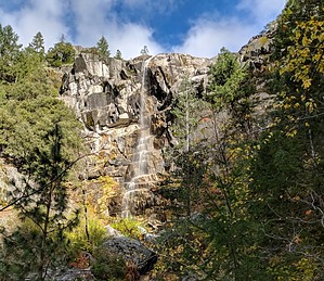
Burstarse Falls is accessed from the PCT, there is a wooden sign in a tree that reads Burstarse Creek. There is a lower falls and upper falls. The upper falls is at least two or three times taller, but more difficult to access. Stay on the east side of the creek as you pass the lower falls. Eventually you will find an area to cross to the west side when the canyon wall makes progressing on the east side not possible. Continue up the canyon, and you'll eventually be able to cross back to the east side for a spectacular view of the large upper falls.
When hiking several trails on a single "hike", log it with a generic name that describes the hike. Then link the trails traveled, check out the example.
WARNING! Hiking and outdoor related sports can be dangerous. Be responsible and prepare for the trip. Study the area you are entering and plan accordingly. Dress for the current and unexpected weather changes. Take plenty of water. Never go alone. Make an itinerary with your plan(s), route(s), destination(s) and expected return time. Give your itinerary to trusted family and/or friends.
Permit $$
no fees or permits reported
if incorrect tell us about it
Directions
Road
To hike From I-5, take the Castella exit. Head west on Castle Creek Road for 3.3 miles. Turn right into the clearing that serves as a parking area. A PCT sign marks the parking area. Hike Dog Trail to the PCT, then hike North on the PCT for about 2 miles until reaching Burstarse Creek.
 Route Editor


