Route Editor

| Guide | ♦ | 50 Triplogs | 1 Topic |
details | drive | no permit | forecast | 🔥 route |
stats |
photos | triplogs | topic | location |
| 786 | 50 | 1 |
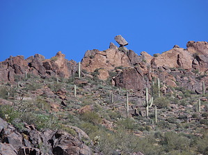
 Background BackgroundReaching the Superstition Mountains highest point fits into several hikes already described on HAZ. This description covers a short seven-mile or so loop out of the Hieroglyphic Trailhead in Gold Canyon that utilizes parts of the Superstition Ridgeline Trail (usually reached via Siphon Draw or Carney Springs) and Hieroglyphics Trail # 101. Both of these trails are magnificent by themselves. Still, the variation described here combines some strenuous hiking with off-trail class three rock scrambling, incredible views, and navigational challenges not otherwise experienced. Note This is not Superstition Peak 5024, which is an unnamed peak situated 1000 feet or so to the northeast of Flatiron.
The hike is probably best done in a counterclockwise manner but could be done clockwise. The scrambling once one leaves the Hieroglyphic Trail to head up to the peak would be most comfortable going up for most people. Surprisingly, there is a faint trail up to the peak, marked by cairns at most essential points. However, a good map and a GPS would be beneficial. The take-off point from trail # 101 for us seemed to be the one most used, and it quickly leads to a faint path up the slope. Don’t miss the huge portal in a large rock formation off to the right. There are few cairns in this section, but the general plan is to make your way up to an outstanding balanced rock on the ridge above Hieroglyphic Springs. If you look around some, some routes to scramble up to the balanced rock will become evident. There is a sharp turn to the right (east) past the balanced rock to head up the ridge. The boulders in this area provide some fun scrambling but obscure the true direction one needs to follow. As they say, “when in doubt, go up…”, but look for the faint trail, which helps immensely along the entire way. You eventually reach a cliff area that you must skirt to the right. Once on top of the cliff, the actual peak will soon come into view. Some of the photographs posted by others show a chair-like rock formation, but we didn’t see it. The views from the top of Superstition Peak are stunning in every direction. Easily recognizable landmarks include Weavers Needle, Four Peaks, Battleship Rock, an oblique view of Flatiron, Picketpost Mountain, and Phoenix's suburbs. You’re also surrounded by some of the most unique rock pillars in the Supes. When ready, head easterly down to intersect the Ridgeline Trail, turn 180 degrees, and go west. There are some fantastic rock formations along the way to the top of Hieroglyphics Canyon, some involving additional scrambling opportunities. The point to turn down Hieroglyphic Canyon is marked with a large cairn. Resist the urge to head down too soon. The trail is relatively easy to follow from here to the springs but very steep and fraught with loose rock. Once the lower drainage is reached, depending on the time of year, water may be flowing. We stayed on the trail due to the considerable flow, but at least one of the tracks linked to this guide goes directly down the drainage. Take some time to view the considerable (but substantially vandalized) rock art near the springs. The slick rock and petroglyphs near and below the spring are truly impressive. Follow the Hieroglyphic Trail back to the parking lot. Check out the Official Route and Triplogs. Note This is a moderately difficult hike. Leave No Trace and +Add a Triplog after your hike to support this local community. | |||||||||||||||||||||||||||||||||||||||||||||||||||||||||||||||||||||||||||||||||||||||||||||||||||||||||||||||||||||||||||||||||||||||||||||||||||||||||||||||||||||||||||||||||||||||||||||||||||||||||||