Route Editor

| Guide | ♦ | 2 Triplogs | 0 Topics |
details | drive | permit | forecast | route |
stats |
photos | triplogs | topics | location |
| 15 | 2 | 0 |
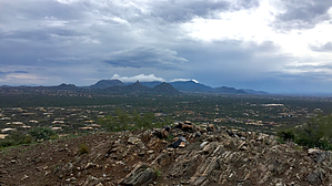
They named a road after it! by chumley  Note NoteThis trail system is now permanently closed to any public access. The ingress and trailhead parking mentioned in this guide at the southern end of Black Cross Road no longer exists. The Desert Foothills Land Trust now offers six docent-guided hikes per year which are open to the public. There is info on their website on how to be notified for this and many other hikes that they offer throughout the year. https://www.dflt.org/ Overview Lone Mountain is a prominent hill that rises about 400 feet above the surrounding desert between Scottsdale, Pima, Dixileta, and Lone Mountain Roads in north Scottsdale.
The mountain is surrounded by residential properties and gated communities. A common access point is from the north at the intersection of Hayden and Lone Mountain Roads where obvious use is apparent. This access point should not be used as it is on private (though undeveloped) property, and is extremely well-signed with private property and no trespassing signs. Hike The public access point begins at the south end of Black Cross Road, 1/4 mile south of Lone Mountain Road. Black Cross Road ends at the preserve boundary fence and provides room for a couple of vehicles to park. The lasso spur from the trailhead switchbacks up a gentle slope until it meets the main loop. Heading to the north slope will lead you up the ridge to the summit. From there the trail switchbacks neatly down the southern ridge before traversing along the eastern slope back north toward the trailhead. The west side of the mountain is owned by the Belasera community and is only open to Belasera residents. There is an access trail about halfway down the north ridge that leads west to the trailhead at the end of Balao Drive. This spur is open only to Belasera residents. The east side is owned by the Wallace Preserve and there are numerous side trails and spurs that cross the preserve and lead to the private Sinquidados community. There is a small parking area and some signage at the main access point for Sinquidados residents in the curve on Las Rocas Drive. All the property between the mountain and the homes in Sinquidados belongs to the preserve. Nonresidents should access the preserve from Black Cross Road. Gate Policy: If a gate is closed upon arrival, leave it closed after you go through. If it is open, leave it open. Leaving a closed gate open may put cattle in danger. Closing an open gate may cut them off from water. Please be respectful, leave gates as found. The exception is signage on the gate directing you otherwise. Check out the Official Route and Triplogs. Leave No Trace and +Add a Triplog after your hike to support this local community. | |||||||||||||||||||||||||||||||||||||||||||||||||||||||||||||||||||||||||||||||||||||