 Route Editor

| Guide | ♦ | 1 Triplog | 0 Topics |
details | drive | permit | forecast | route |
stats |
photos | triplog | topics | location |
| 7 | 1 | 0 |
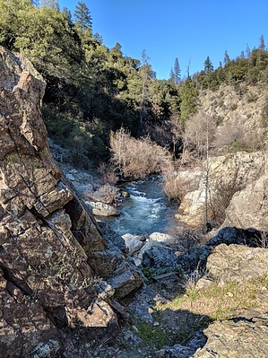
finger pointing upwards by HAZ_Hikebot  pine and manzanita. Get back on the main trail where it intersects with the handicap pathway to the overlook. The trail winds steadily down the rim of the creek canyon for the remainder of its length. Mining remnants can be seen in this area. Look for small terraces once occupied by mining equipment and buildings. A collapsed mining shaft is located on a level area shortly before the next fork in the trail. Stay out and stay alive! At the fork in the trail, you have the choice of continuing straight ahead or veering off to the left at the sign that says “Guardian Rock.” Take the left fork to the bottom of this trail if you would like the scenic view of Guardian Rock, a large outcropping that looks almost like a finger pointing upwards. This side trail continues upward and meets the main trail. The next section of trail parallels an old mining road that is supported by an extensive rock wall. Soon you will see the bridge leading to the NEED Camp and you will come to a crossing with seasonal Orofino Creek. You can return the way that you came, or make a loop back to Horse Camp by following the trail sign which leads to the right. This trail ends at Paige Bar Road, a dirt road which will lead you back to your starting point at Horse Camp. A short ways along the road, you will pass over Orofino Creek near a mineral seep – notice the usually strong odor of sulfur. The pine trees in the area are often occupied by flocks of band-tailed pigeons that drink at the mineral springs. Horse Camp has a restroom and a faucet with potable water turned on during the warm months of the year.
Check out the Official Route and Triplog. Leave No Trace and +Add a Triplog after your hike to support this local community. One-Way Notice This hike is listed as One-Way. When hiking several trails on a single "hike", log it with a generic name that describes the hike. Then link the trails traveled, check out the example. | |||||||||||||||||||||||||||||||||||||||||||||||||||||||||||||||||||||


