Route Editor

| Guide | ♦ | 3 Triplogs | 0 Topics |
details | drive | permit | forecast | map |
stats |
photos | triplogs | topics | location |
| 45 | 3 | 0 |
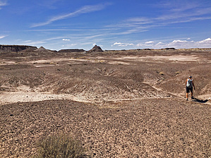
  Warning WarningThe approach is questionable. Do not park where signage explicitly forbids parking. Do not enter any area on planet earth where official signage forbids entering. This one-mile (1.6 km) hike takes you to a petroglyph site at the base of a feature called Martha’s Butte. A solar marker petroglyph, which appears sliced in half by the summer solstice sunrise, and many other petroglyphs can be seen on rocks surrounding the butte. The origin of the name Martha’s Butte or who Martha was is unknown. The following is a suggested route, not a trail, route finding skills will be used on this hike. Park at the Dry Wash bridge just south of milepost 22 on the main park road – there is a small, unimproved place to park on the south side of the wash, off the northbound lane. Begin heading north following Dry Wash – as the wash bends sharply east, head northwest towards Martha’s Butte.
If you go to the smaller hill south of Martha’s Butte, you will see a large petrified log embedded in the clay hill. This was long thought to be a petrified stump still in place but was excavated in 1936 by park naturalist Myrl V. Walker and some CCC “boys”, revealing that it is a log portion at a steep angle. This log section is now known as “Walker’s Stump”. Please respect the visitors who follow you and leave all petrified wood and artifacts in place. Be careful not to touch the petroglyphs. Oils on your hands can cause damage. This walk, although not difficult or steep, does require sturdy shoes. The footing can be difficult at any time. Do not attempt this hike if lightning is in the area. Please take normal hiking precautions and bring food and water, sun protection, and navigation aids. Pack out whatever you packed in.
Check out the Triplogs. Leave No Trace and +Add a Triplog after your hike to support this local community. | |||||||||||||||||||||||||||||||||||||||||||||||||||||||||||||||||||