Route Editor

| Guide | ♦ | 8 Triplogs | 0 Topics |
details | drive | permit | forecast | route |
stats |
photos | triplogs | topics | location |
| 98 | 8 | 0 |
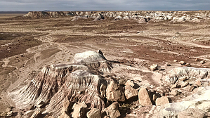
Nest Unoccupied by HAZ_Hikebot   This 2.5-mi round trip hike along the old 1930’s road into Jasper Forest is a pleasant stroll through an incredible garden of petrified wood. This area, originally called First Forest because it was the first collection of petrified wood travelers encountered when they came by wagon from the Adamana train station one hundred years ago. The road within Jasper Forest was added later for car traffic. The road is mostly eroded now, but you can still follow it if you look carefully for the old gravel. This 2.5-mi round trip hike along the old 1930’s road into Jasper Forest is a pleasant stroll through an incredible garden of petrified wood. This area, originally called First Forest because it was the first collection of petrified wood travelers encountered when they came by wagon from the Adamana train station one hundred years ago. The road within Jasper Forest was added later for car traffic. The road is mostly eroded now, but you can still follow it if you look carefully for the old gravel.Please respect the visitors who follow you and leave all petrified wood, fossils, artifacts, and natural objects in their places.
Jasper Forest is one of the largest deposits of petrified wood in the park. These petrified log segments were encased initially in the sandstone bluffs above the road, but thousands of years of erosion have sent them tumbling down into the valley. This gravel road you are following was constructed by the Civilian Conservation Corp in the mid-1930s. The road was closed in November of 1965 and replaced by the upper road to the present parking lot and overlook. You can still see many of the original stone culverts lining the old roadbed where it crosses a wash. The end of the road looped around a geological feature called Eagle Nest Rock. The feature fell in January 1941 after a period of unusually heavy rain. However, you can still see the base in the center of the loop.
Check out the Official Route and Triplogs. Leave No Trace and +Add a Triplog after your hike to support this local community. | ||||||||||||||||||||||||||||||||||||||||||||||||||||||||||||||||||||||||||||||||||||||||||||||||||||||||||||||||||||||||||||||||||||||||||||||||||