username
X
password
register
for free!
help
 

Dragonfly Loop Trail #720, NM

Guide 6 Triplogs  0 Topics
  3 of 5  
Fav
Wish
0
details
drive
no permit
forecast
route  
stats
photos
triplogs
topics
location
44 6 0
Statistics
tap row or icons for details
Difficulty 1 of 5
Distance One Way 3.52 miles
Trailhead Elevation 6,144 feet
Elevation Gain 139 feet
Accumulated Gain 246 feet
Kokopelli Seeds 4.34
feature photo
Photos Viewed All MineFollowing
Inaugural Calculation on Button Tap!
15  2025-08-14
Dragon Fly Loop
markthurman53
5  2024-03-12 chrisbjohnson
6  2017-05-23 Nightstalker
33  2017-04-22 rwstorm
Author
author avatar Guides 16,843
Routes 17,472
Photos 24
Trips 1 map ( 6 miles )
Age 28 Male Gender
Location HAZ, TrailDEX
Associated Areas
list map done
Southwest Region
Historical Weather
Trailhead Forecast
Radar Map
Expand Map
Preferred Mar, Nov, Apr, Oct
Sun  5:49am - 6:34pm
Official Route & 2 Rts
 
1 Alternative


The trail is open to pedestrians/hikers, cyclists

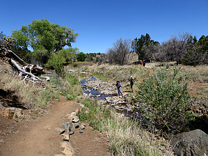
Dragonfly Trail is most known for the petroglyphs located approximately 2 miles from the trailhead. Here visitors can see petroglyphs, enjoy the many live dragonflies during the right months and take in the breathtaking scenery.


While enjoying the petroglyphs make sure to:
remove free decal offer
Take pictures
Document where you see petroglyphs in a written form, i.e., a journal
Leave only footprints; take only memories
Respect ancient cultural artifacts
Never deface rock art or attempt to remove the rock art
Never build fires near the rock art
Avoid climbing or leaning on the rock art
Never chalk, trace or apply anything to the rock art panels
Do not touch the petroglyphs as the oils from your hands can damage or change the pigments of the rock art

2018-09-12 HAZ_Hikebot
  • Fort Bayard Trail System
    area related
    Fort Bayard Trail System
  • Fort Bayard Trail System - 2
    area related
    Fort Bayard Trail System - 2
  • Fort Bayard Trail System - 3
    area related
    Fort Bayard Trail System - 3


Check out the Official Route and Triplogs.
Leave No Trace and +Add a Triplog after your hike to support this local community.

One-Way Notice
This hike is listed as One-Way.

When hiking several trails on a single "hike", log it with a generic name that describes the hike. Then link the trails traveled, check out the example.
WARNING! Hiking and outdoor related sports can be dangerous. Be responsible and prepare for the trip. Study the area you are entering and plan accordingly. Dress for the current and unexpected weather changes. Take plenty of water. Never go alone. Make an itinerary with your plan(s), route(s), destination(s) and expected return time. Give your itinerary to trusted family and/or friends.

 Permit $$
no fees or permits reported

if incorrect tell us about it


 Directions
or
 Road


To hike
The Dragonfly Trailhead is located roughly 3 miles east of Silver City on the north side of US Highway 180.

page created by joebartels on Apr 19 2017 7:25 am
 90+° 8am - 6pm kills
helpcorrectionissue

end of page marker