 Route Editor

| Guide | ♦ | 2 Triplogs | 0 Topics |
details | drive | no permit | forecast | route |
stats |
photos | triplogs | topics | location |
| 0 | 2 | 0 |
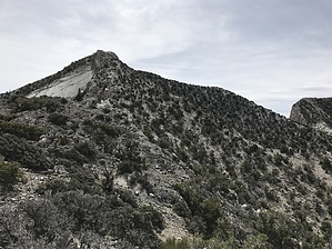
La Madre Wilderness Highpoint by LindaAnn From the Upper Parking Area, continue walking southeast up the road another 0.40 miles to the La Madre Wilderness sign. La Madre Peak is clearly visible to the southeast, and you can view the ridge you will ascend to the summit. At the sign, turn left, heading east, descending quickly across a wash and up the other side. The ridge is directly in front of you, although obscured by juniper. The ridge is about 0.10 miles east of the sign.
Not too far below the summit, the grey rocks give way to some bouldery-type rocks, and the final part of the ascent looks somewhat intimidating. The ridge turns to a spine of sorts, but the footing remains good, never seems to narrow below four feet wide, and there's no real exposure to be concerned with. Carefully scramble up this section, enjoy the slabs of exposed rock below you on your left, and near the top, the route levels out somewhat leading to an easy final hike up to the summit. The summit has places to sit and rest while enjoying great views in nearly every direction. El Padre peak obscures some of the view to the southwest, which is a good incentive to hike over to El Padre to gain the better southern views. After you've had your fill of the summit, you either retrace your steps back down the ridge, or head over towards El Padre, which is 0.85 miles and 400' aeg away, which would allow you to turn this into a loop hike. Check out the Official Route and Triplogs. Note This is a moderately difficult hike. Leave No Trace and +Add a Triplog after your hike to support this local community. One-Way Notice This hike is listed as One-Way. When hiking several trails on a single "hike", log it with a generic name that describes the hike. Then link the trails traveled, check out the example. | ||||||||||||||||||||||||||||||||||||||||||||||||||||||||||||||||||||||||||||||||||


