 Route Editor

| Guide | ♦ | 2 Triplogs | 0 Topics |
details | drive | permit | forecast | route |
stats |
photos | triplogs | topics | location |
| 27 | 2 | 0 |
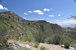
The easier way by markthurman53  The Rio Grande River comes down out of Colorado heads south through New Mexico and passes through El Paso Texas where it now becomes the border between the United States and Mexico. The river flows 1254 miles in a South East direction toward the Gulf of Mexico but before getting there it makes a turn to the North East, creating a momentary bend in the river, This Is Big Bend National Park. The mountains in this park are a continuation of a mountain range in Mexico which will continue up into the US through Guadalupe National Park and into New Mexico. The highest Point in this park is Emory Peak at 7800 feet. This park is probably one of the remotest parks in the contiguous United States but despite being in the middle of nowhere has a lot to offer in hiking, camping and general sightseeing. LAGUNA MEADOW TRAIL
The Laguna Meadow Trail is one of two trails that lead up to the Chisos Mountains from Chisos Basin. The trail starts at the visitor center in Chisos Basin and heads up to Laguna Meadow just before the termination of the trail at the junction with the South Rim and Colima Trails. This trail is the more gradual route from the Chisos Basin to the upper Chisos Mountains; of course it is longer than the alternate Pinnacles Route. Laguna Meadow is about 1000 feet below the west side of Emery Peak. Be prepared to bring all water you will require because water in the Chisos Mountains is not always available. Description The trail starts at the west end of the visitor center parking lot. The trail is signed and for the first quarter mile the Laguna Meadow and the Pinnacles Trail share the same path. At a signed junction the Laguna Meadow Trail spits off to the right (west). The first 1.4 miles is a gradual grade gaining only 300 feet and follows along and to the east of Oak Canyon. From this section of trail Emory Peak can be seen towering above and most of Oak Canyon is visible all the way toward Window Canyon. The next 1.7 miles the trail kicks up the climb a little, gaining 1000 feet where you arrive just above Laguna Meadow. Laguna Meadow is situated in a flat between two creeks, this flat separates Oak Creek which drain to the north and Blue Creek which drains toward the south. Camping is permitted in this area. Just past Laguna Meadow the Blue Creek Trail intersects the Laguna Meadow Trail and heads down Blue Creek to the South. The Laguna Meadows Trail continues for another half mile where it ends at the junction with the South Rim and Colima Trails. The final 250 feet up to the top of the rim is done along the South Rim Trail. If your destination is Emory peak, the Colima Trail to the Boot Canyon Trail is your route and you now are at about the same elevation as the saddle between Emory Peak and Toll Mountain and the start of the Emory Peak Trail. The Laguna Meadow Trail is well maintained and signed and since it has a gentler slope than the Pinnacles Trail this is often chosen as the up approach on a loop hike to Emory Peak or the Rim Trails. Views along this trail are pretty much limited to the west 180 degrees but there is a vast area out there and only limited by how clear it is. Check out the Official Route and Triplogs. Leave No Trace and +Add a Triplog after your hike to support this local community. One-Way Notice This hike is listed as One-Way. When hiking several trails on a single "hike", log it with a generic name that describes the hike. Then link the trails traveled, check out the example. | ||||||||||||||||||||||||||||||||||||||||||||||||||||||||||||||||||||||||||||||||||||||


