Route Editor

| Guide | ♦ | 14 Triplogs | 0 Topics |
details | drive | permit | forecast | route |
stats |
photos | triplogs | topics | location |
| 209 | 14 | 0 |
Canyons are inherently risky. Flash floods occur without notice on sunny days. Technical skills & surrounding topography knowledge required yet does not eliminate risk.
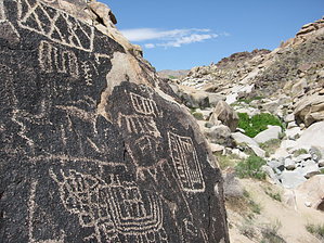
Historical, Artistic & Significant by AZLOT69 The Grapevine Canyon trailhead is located adjacent to a wide wash and is equipped with a restroom but no water. The trail starts from the west end of the parking area with one branch heading into the wash while another stays on the left bank of the wash. Either is fine but walking in the wash on grade is like walking on the beach. Arriving at the mouth of the canyon in just a quarter mile, you are met with virtual billboards made up of petroglyphs. Huge panels both low and high and on both sides, line the opening of the canyon. This is the largest collection of petroglyphs in southern Nevada. The panels are further believed to extend 30 to 50 feet below the surface which has not been excavated. Some interpret the panels as an attempt to describe the creation of the vast valley to the east by the ancients. Whatever the interpretation, one thing agreed upon is that this was a regular meeting place for prehistoric people for possible thousands of years. Most people end their adventure this point or casually walk north or south of the wash at this point along the rock outcroppings and examine more petroglyphs in the varnished rock. Hike Entering the Grapevine Canyon requires some bouldering and scrambling. The petroglyphs extend for a ways into the canyon but the geology changes and the varnished rocks end, replaced with granite and white rock. While listed as one way out and back you can make this a narrow loop. Described here as clockwise, heading in on the south side of the wash and returning on the north side. Working along the south side of the dry wash continue up and over the rock in a westerly direction. The canyon narrows and the wash becomes more like a creek with generally a nominal flow of water. It is full of cattail and arrow- weed. About a half mile into the hike and after scrambling up some slick white rock the creek opens up in front of you like a fertile valley. It is very green and appears as an oasis complete with towering ancient cottonwood trees. The aroma in the air in late April is intoxicating. Countless canyon grape vines the choke creek area. Staying on the south bank of the reappearing wash skirts the majority of the vegetation but on occasion you will be pushing thru the grape vines. They are as thick as a jungle but soft to the touch, easy to move thru, and break off quite easily. The grapevine area ends and desert like conditions return. Slick white rock fills the canyon bottom as the sun acts like a convection oven reflecting the heat towards the canyon bottom. The water disappears for a quarter mile then around a bend the water and the grapevines return. Cottonwoods again tower above the creek. You have arrived at Moss Spring. There are many potential camp sites here with several bushwhack day hike possibilities. Canyons both north and south of Grapevine beg to be explored. Continuing on to the west of Moss Spring, the Mohave returns and the now sandy wash is lined with crumbling granite rock. Awesome white rock spires line the western horizon as you continue into the Bridge Canyon Wilderness. Another oasis is evident ahead marked with cottonwood trees. There is no water at the surface here and some of these very old trees have surrendered to the elements. Working thru this section, the wash further widens becoming very sandy. Then a wonderful slot is center stage in the wash. It only runs for about a quarter mile and could be avoided but why ? Those towering spires of white rock are close now and Grapevine Canyon comes to a box canyon type end. You could continue from here with a climb but this is a natural turn around for a day hike. Return now on the left (north)side of the wash. It gives a very different feeling than a simple out and back. The different obstacles keep things interesting especially as you get back to the mouth of Grapevine. The north side offers some interesting rock down climbs. Back at the mouth of the canyon you can see the trailhead. You can continue along the north bank, hike down the wash or return on the south bank to the trailhead. Walking down the wash, you will almost certainly be rewarded with sightings of the large quantity and variety of lizards here. Roundtrip distance about 4.5 miles. Check out the Official Route and Triplogs. Leave No Trace and +Add a Triplog after your canyon trip to support this local community. | |||||||||||||||||||||||||||||||||||||||||||||||||||||||||||||||||||||||||||||||||||||||||||||||||