Route Editor

| Guide | ♦ | 6 Triplogs | 0 Topics |
details | drive | no permit | forecast | route |
stats |
photos | triplogs | topics | location |
| 53 | 6 | 0 |
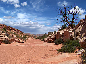
Its a sand trap! by PaleoRob  From the parking area, proceed towards the gate in the fenceline visible to the south. From there it is easy to make your way down to the canyon bottom, which is very shallow and partially covered in sand at this point. Begin hiking upcanyon, away from the highway.
Soon after passing the barbed wire, the canyon begins to deepen. Dozens of small arches and windows appear in the canyon walls. About .6 miles upcanyon from the trailhead you come to a series of seeps on the southeastern canyon wall. They can be recognized before you reach them by a few scattered tamarisks and some hanging mosses. The water drips almost painfully slowly, but it is good water to drink. Since this is generally just a dayhike, however, you should plan to bring your own water and not rely on this seep. The spring disappears around a bend and you come the first in a series of pourovers. These pourovers are not too high, and can be bypassed on the right (northwest) side of the canyon. The real difficulty of this hike to view the arch is the sandy wash bottom. While around some of the pourovers fluted sandstone appears, most of the wash is sand. Coarse sand that gets in your shoes despite your best efforts. It really slows down your hiking. You continue upstream for about another half mile past the pourovers, and Birthday Arch comes into view. If you want to hike up to a point underneath the arch, it requires another .5-.75 mile scramble up the rocks below arch, often times with lots of backtracking and trying to find the best route up. The rewards are worth it, however. Once you have made it to the arch, you can return to your vehicle via the canyon, or attempt head upstream a bit more into a slotty narrows section. Remember to always stay out of slot canyons if rain is possible! Once you have seen the arch and the slot, head back into the canyon. An overland route due north across the dunes is possible, but for those inexperienced in the art and pain of hiking across desert sand dunes, the canyon route is recommended. Gate Policy: If a gate is closed upon arrival, leave it closed after you go through. If it is open, leave it open. Leaving a closed gate open may put cattle in danger. Closing an open gate may cut them off from water. Please be respectful, leave gates as found. The exception is signage on the gate directing you otherwise. Check out the Official Route and Triplogs. Leave No Trace and +Add a Triplog after your hike to support this local community. | |||||||||||||||||||||||||||||||||||||||||||||||||||||||||||||||||||||||||||||||||||||