 Route Editor

| Guide | ♦ | 25 Triplogs | 0 Topics |
details | drive | no permit | forecast | route |
stats |
photos | triplogs | topics | location |
| 65 | 25 | 0 |
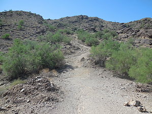
neighborhood shortcut by trekkin_gecko  HAZ Notice HAZ NoticeUse at your own risk. This trail is not listed by the managing agency park service. Hiking undesignated park trails might get you a ticket. Check for park signage. Hike While looking at the South Mountain map when posting other hikes, I've noticed this trail. It begins where South Mountain avenue dead-ends just east of 28th street. A groomed gravel bike path runs east to 32nd street, crosses the street, and picks up on the other side as a rockier dirt path. Skirting a gated housing development, the path turns south and starts to gain elevation at an easy grade. The grade gets steeper and the trail rockier, heading south and occasionally west past a couple of drainages and several large boulder piles. Footing is a mix of sand, loose rock, and bedrock. One section is loose and eroded, probably made worse by yesterday's monsoon storm. The grade is moderate, gaining 650 feet in less than a mile. Eventually, the trail tops out at one of the high points along Mormon Loop Trail. There is a small line of rocks and a cairn to mark that point.
Gate Policy: If a gate is closed upon arrival, leave it closed after you go through. If it is open, leave it open. Leaving a closed gate open may put cattle in danger. Closing an open gate may cut them off from water. Please be respectful, leave gates as found. The exception is signage on the gate directing you otherwise. Check out the Official Route and Triplogs. Leave No Trace and +Add a Triplog after your hike to support this local community. One-Way Notice This hike is listed as One-Way. When hiking several trails on a single "hike", log it with a generic name that describes the hike. Then link the trails traveled, check out the example. | |||||||||||||||||||||||||||||||||||||||||||||||||||||||||||||||||||||||||||||||||||||||||||||||||||||||||||||||||||||||||||||||||||||||||||||||||||||||||||||||||||||||||||||||||||||||||


