username
X
password
register
for free!
help
  

Children's Cave Trail - Picacho State Park, AZ

Guide 8 Triplogs  0 Topics
  3 of 5  
Fav
Wish
0
details
drive
permit
forecast
route  
stats
photos
triplogs
topics
location
47 8 0
Statistics
tap row or icons for details
Difficulty 0.5 of 5
Route Finding 1 of 5
Distance One Way 0.16 miles
Trailhead Elevation 1,916 feet
Elevation Gain 83 feet
Accumulated Gain 83 feet
Avg Time One Way 0.25 hours
Kokopelli Seeds 0.44
unreported if dogs are allowed
editedit > ops > dogs to adjust
feature photo
Photos Viewed All MineFollowing
Will recalculate on button tap!
7  2020-11-06 fricknaley
15  2019-03-11
Calloway Trail - Picacho State Park
Tortoise_Hiker
18  2017-07-22
Picacho Loop
jacobemerick
7  2017-01-24
Calloway Trail / Children's Cave / Plaground
Tortoise_Hiker
Author
author avatar Guides 38
Routes 182
Photos 1,602
Trips 232 map ( 2,731 miles )
Age 40 Male Gender
Location Gilbert, AZ
Associated Areas
list map done
Tucson Region
Historical Weather
Trailhead Forecast
Radar Map
Expand Map
Preferred Jan, Dec, Feb, Nov
Sun  6:02am - 6:47pm
Official Route
 
2 Alternative


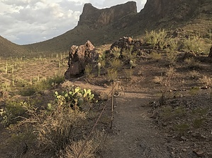
Short Trail to a Little Cave
by jacobemerick

Overview
Picacho Peak State Park has more than the tough and challenging trail to the top of the peak. There is a little nook called Children's Cave on a small hill at the end of a short trail that is perfect for family hiking.


Hike
Right at the beginning of Barrett Loop are some parking spots, a restroom, and a small sign for Children's Cave Trail. Park here and follow the trail from the sign, which immediately crosses a shallow wash over a well-built bridge. Then the trail continues west, with a few informative signs along the way, slowly gaining elevation. There is a bend to the left and a little bit more climb, with some cables for some protection against the downhill next to the trail before the cave shows up. The cave itself is just tall enough for an adolescent to walk in without ducking (thus the name, probably) and is only a few feet deep.
remove free decal offer
There are a few other cool things near here to check out, depending on the group. A few dozen yards up the road from the trailhead is a small playground area with some of the coolest swings I've seen. There are several pavilions for picnics and plenty of unnamed trails, some connecting to Nature Trail, to bump up the total mileage of your hike.

2017-08-10 jacobemerick
  • sub-region related


Check out the Official Route and Triplogs.
Leave No Trace and +Add a Triplog after your hike to support this local community.

One-Way Notice
This hike is listed as One-Way.

When hiking several trails on a single "hike", log it with a generic name that describes the hike. Then link the trails traveled, check out the example.
WARNING! Hiking and outdoor related sports can be dangerous. Be responsible and prepare for the trip. Study the area you are entering and plan accordingly. Dress for the current and unexpected weather changes. Take plenty of water. Never go alone. Make an itinerary with your plan(s), route(s), destination(s) and expected return time. Give your itinerary to trusted family and/or friends.

 Permit $$
AZ State Parks more info
2023 Day Use Fees range from $2–$30


 Directions
or
 Road
Paved - Car Okay

To hike
Between Phoenix and Tucson on Interstate 10 Exit 219. Follow the signs to Picacho State Park. Turn left about 1/2 miles past pay station and park right at the beginning of the Barrett Loop.
page created by jacobemerick on Aug 09 2017 9:05 pm
 90+° 8am - 6pm kills
helpcorrectionissue

end of page marker