 Route Editor

| Guide | ♦ | 3 Triplogs | 0 Topics |
details | drive | no permit | forecast | route |
stats |
photos | triplogs | topics | location |
| 37 | 3 | 0 |
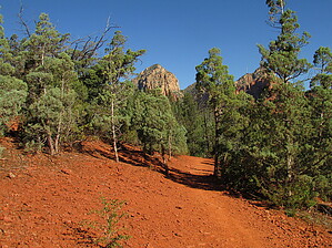
YOU DONT KNOW.....Adobe Jack! by mt98dew   Overview OverviewAdobe Jack Trail is one of eight new trails that were created when the Adobe Jack TH was created in 2016. This TH is directly off the 89A just past Mariposa Grill. There is enough parking for only 5 vehicles. Currently, there is home construction occurring just west of the TH so parking may be even more impacted. There is no fee for parking at this TH. At the TH there is a great map of the Sedona trail system as well as a localized map of the Adobe Jack (Soldier Wash Trails). There is also a bike repair station which is becoming a common theme with some of the more established Arizona TH. However, there are no restrooms or water at this TH so come prepared. Hike The Adobe Jack Trail is stated as being 2.25 miles long. (My Garmin has it coming in at 2.1 miles). The trail starts by dropping down and crossing a wash. Note the laid stones at the crossing. This trail has several such ramps to assist bikes in their climbs. After the wash, the trail climbs a little and junctures with Crusty Trail. The trail then follows the contours of the slopes providing decent views of the forested valley and Munds Mountain to the east as well as Wilson Mountain to the north. At about 0.45 miles the trail begins a gradual descent where it connects to the Coyote Trail. The Adobe Trail continues to the north crossing another stone ramped wash. The trees creep in and the slopes of the hills rise providing a tranquil and fleeting feeling of intimacy. Almost immediately the trail leaves this shaded oasis and climbs up the northern slope. This is probably the toughest climb of the trail, but it doesn't last long and quickly brings you to the next trail juncture - Powerline Plunge Trail. Just after this connection, (about 0.86 miles from the TH) the trail comes to a small, but nice mesa overlooking the surrounding area. Almost immediately, 0.96 miles there is another trail connection with the Manzanita Trail. It may feel that the trail descends from here and does for a short time, before holding level and then beginning an imperceptible rise. The trail enters a stretch where it becomes practically rock-free being composed of compact dirt layered by a soft powder. The trail does a lot of twisting and turning. Ideal for bikers. The views during this time are rather ordinary....and that is saying something for Sedona. The surrounding hills and the vegetation isn't overly thick, but they do a good job of minimizing the Sedona Mountainscape. There is a dry creek that joins the geography for about 0.4 miles and that adds a little variety to the views. As the trail starts a gradual, but definite climb the views start to pick up again. The trees become a companion with the trail, providing shade and periodic peeks of the rising mountains looming before you. At around 2 miles there is another trail connection, this time to the Grand Central Trail. This juncture is not signed as such, but there is a trail map at the juncture and one can deduce the trail name. At 2.2 miles the trail ends with its juncture to the Jordan Trail.
Check out the Official Route and Triplogs. Leave No Trace and +Add a Triplog after your hike to support this local community. One-Way Notice This hike is listed as One-Way. When hiking several trails on a single "hike", log it with a generic name that describes the hike. Then link the trails traveled, check out the example. | |||||||||||||||||||||||||||||||||||||||||||||||||||||||||||||||||||||||||||||||


