username
X
password
register
for free!
help


Myrtle Point 7920, AZ

Guide 8 Triplogs  2 Topics
  2.8 of 5  
Fav
Wish
0
details
drive
no permit
forecast
map
stats
photos
triplogs
topics
location
63 8 2
Statistics
tap row or icons for details
Difficulty 0.5 of 5
Route Finding 1 of 5
Distance Round Trip 1.3 miles
Trailhead Elevation 7,830 feet
Elevation Gain 90 feet
Accumulated Gain 300 feet
Avg Time Round Trip 30 minutes
Kokopelli Seeds 2.8
 Interest Off-Trail Hiking & Peak
 Backpack Yes
feature photo
Photos Viewed All MineFollowing
5  2024-08-11
Myrtle Point Direct
pseudalpine
14  2024-05-23
Myrtle - Babe Loop
joebartels
20  2024-05-23
Myrtle - Babe Loop
The_Eagle
15  2024-05-23
Myrtle - Babe Loop
wallyfrack
4  2023-06-23
Myrtle Point Loop
pseudalpine
30  2022-10-15
Autumn on the rim
chumley
15  2020-09-30 DixieFlyer
48  2018-04-26
Fish Hatchery to Knoll Lake and Myrtle Point
DixieFlyer
Author
author avatar Guides 99
Routes 1,484
Photos 16,072
Trips 1,374 map ( 13,602 miles )
Age Male Gender
Location Fountain Hills, AZ
Associated Areas
list map done
Payson Region
Historical Weather
Trailhead Forecast
Expand Map
Preferred Apr, May, Oct, Nov → Early
Seasons   Spring to Late Autumn
Sun  6:00am - 6:47pm
3 Routes
 
5 Alternative


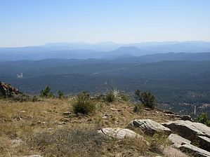
Gila County High
by DixieFlyer

  
Overview
Myrtle Point and Promontory Butte are the co-Gila County Highpoints.


Note
The HAZ County High Point completion list requires attaining both Promontory Butte and Myrtle Point to check off Gila County.
remove free decal offer
Hike
This hike begins and ends at the "trailhead," which is at the junction of Rim Road 300 and FR 300C. This is not far from the turn off of Rim Road 300 that goes to Knoll Lake. You can either drive or hike to the trailhead. If hiking, starting at the Hatchery TH, and taking the Babe Haught Trail up to the Rim is a logical choice. Check triplogs for other ideas.

Hike south on FR 300C for around 1/2 mile and then go off-trail to the west for a very short distance to attain the Gila County co-highpoint. There is no sign at the off-trail turn. A GPS track might be helpful.

You'll see a summit cairn and a trip logbook; the highpoint is a few feet south of the cairn, at the edge of the Rim. Be careful not to fall off the Rim though!

Enjoy the fabulous views of the mountains off in the distance, and then return the way that you came.

Camping
Dispersed camping sites are available along FR 300C. There are also several other places to camp off of Rim Road 300.

2020-10-01 DixieFlyer


    Check out the Triplogs.
    Leave No Trace and +Add a Triplog after your hike to support this local community.
    WARNING! Hiking and outdoor related sports can be dangerous. Be responsible and prepare for the trip. Study the area you are entering and plan accordingly. Dress for the current and unexpected weather changes. Take plenty of water. Never go alone. Make an itinerary with your plan(s), route(s), destination(s) and expected return time. Give your itinerary to trusted family and/or friends.

     Permit $$
    None


     Directions
    or
     Road
    FR / Jeep Road - Car possible when dry

    To hike
    The trailhead for this hike is the junction of Rim Road 300 and FR 300C. When dry, most sedans can negotiate the drive on Rim Road 300, although a bit of clearance will be helpful.
    page created by chumley on Oct 01 2020 6:19 am
     90+° 8am - 6pm kills
    helpcorrectionissue

    end of page marker