Ringtail Trail - Saguaro NP West, AZ | HikeArizona
  

Ringtail Trail - Saguaro NP West, AZ

Guide 11 Triplogs Mine 0 0 Topics
 
2 of 5 
Fav
Wish
0
details
drive
permit
forecast
route  
stats
photos
triplogs
topics
location
4 11 0
Statistics
tap icons for details
Difficulty 1 of 5
Distance One Way 1.1 miles
Trailhead Elevation 2,384 feet
Elevation Gain 90 feet
Accumulated Gain 115 feet
Avg Time One Way 0.5 hours
Kokopelli Seeds 1.48
 Backpack No
 Dogs not allowed
feature photo
Photos Viewed All MineFollowing
4  2021-02-27
Ironwood Forest Trail - Saguaro NP West
chumley
4  2017-08-24 markthurman53
20  2017-08-24
SNP West Thunderbird Cactus Canyon Loop
markthurman53
Author
author avatar Guides 187
Routes 851
Photos 10,108
Trips 686 map ( 5,820 miles )
Age 69 Male Gender
Location Tucson, Arizona
Associated Areas
list map done
Tucson Region
Historical Weather
Trailhead Forecast
Radar Map
Expand Map
Preferred Jan, Dec, Feb, Nov → 8 AM
Seasons   Autumn to Late Spring
Sun  6:53am - 6:21pm
Official Route
 
3 Alternative
 
 Water
Nearby Area Water
[ View More! ]
no photo labels yet
+Add > Photos to this Guide
then label as applicable
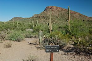
Another trail to nowhere
by markthurman53

Overview
This trail will most likely be used as part of a larger loop hike since its endpoint is not at any trailhead. The trailhead is at the parking lot along the Picture Rocks Road just west of Contzen Pass and heads south to the Picture Rocks Wash Trail 1.1 miles later. The Ringtail Trail has an elevation gain of about 80 feet and skirts the west side of Picture Rocks Peak.


Hike
The Ringtail trail starts at the parking lot just West of Contzen Pass in a wash on the south side of Picture Rocks Road. At 0.1 miles is the signed junction with the Cam-Boh Trail, continue South along the Ringtail Trail. This trail continues along a wash for another 0.1 miles before exiting the wash to the right (west). This exit point is not marked, but it is not hard to see, and the wash starts to get a little narrow and covered with brush at this point. Follow this trail along the west side of the wash, and at 0.4 miles in from the start is the signed junction with the Mule Deer Trail that heads west to the Ironwood Trail. Continue south along the Ringtail Trail, and it will cross the creek again and continue up to a slight ridge to the southwest of Picture Rocks Peak. The trail continues staying relatively level in a southeasterly direction. From this section of the trail in the distance to the Southeast is the old abandon Yume Mine, one of the two profitable mines in Saguaro National Park. At 1.1 miles in, the Ringtail Trail ends at the signed Picture Rocks Wash Trail. If visiting the Old Yuma Mine, there is a route that heads to the southeast from the Picture Rocks Wash at this point. This trail is easy to follow; the only place to be on the lookout for the trail exit from the wash at 0.2 miles in from trail start. From the end point of the trail there are multiple options to make this a longer loop hike, Picture Rocks Wash west to the Cactus Canyon Trail or further west along the Wash to Ironwood Forest Trail or Brittlebush Trail.

Check out the Official Route and Triplogs.

Leave No Trace and +Add a Triplog after your hike to support this local community.

2017-08-25 markthurman53
  • Rincon HAZ Map
    area related
    Rincon HAZ Map
  • Rincon Mountain Distric East
    area related
    Rincon Mountain Distric East
  • Tucson Mountain District West
    area related
    Tucson Mountain District West
  • SNP Cactus Forest Map
    area related
    SNP Cactus Forest Map
  • nps related
  • sub-region related

One-Way Notice
This hike is listed as One-Way.

When hiking several trails on a single "hike", log it with a generic name that describes the hike. Then link the trails traveled, check out the example.
WARNING! Hiking and outdoor related sports can be dangerous. Be responsible and prepare for the trip. Study the area you are entering and plan accordingly. Dress for the current and unexpected weather changes. Take plenty of water. Never go alone. Make an itinerary with your plan(s), route(s), destination(s) and expected return time. Give your itinerary to trusted family and/or friends.

 Permit $$
NPS

Saguaro National Park
2022 $25 vehicle • $20 motorcycle • $15 individual on foot or bicycle
Receipt is valid for 7 days
$45 Annual Park Pass View All


 Directions
or
or
 Road
Paved - Car Okay

To Cam-Boh Trailhead
From Tucson take exit 246 off I-10 and go west on Cortaro until it ends at a T. Turn right here onto Ina for a short distance, then Left onto Wade. Wade quickly becomes Picture Rocks Road and crosses through the Tucson Mountains. You'll see a couple of signs announcing Saguaro National Park. As you come down the west side of the mountains, just beyond Contzen Pass, the road swings hard to the right and there is a paved pull out area to the right. This is the Ringtail trailhead. Continue on Picture Rocks Road for about 2.5 more miles heading west. You will see a brown sign for the Cam-Boh picnic area on your left, just as you see a sign announcing you are about to leave the park. Pull in the Cam-Boh picnic area and park.

From PHX (I-10 & AZ-51) 106 mi - about 1 hour 42 mins
From TUC (Jct 1-10 & Grant) 14.4 mi - about 26 mins
From FLG (Jct I-17 & I-40) 250 mi - about 3 hours 47 mins
page created by markthurman53 on Aug 25 2017 11:33 am
helpcorrectionissue

end of page marker