 Route Editor

| Guide | ♦ | 3 Triplogs | 0 Topics |
details | drive | permit | forecast | route |
stats |
photos | triplogs | topics | location |
| 3 | 3 | 0 |
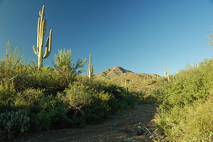
The less traveled trail by markthurman53  Overview OverviewThis trail starts along the Thunderbird trail 0.4 miles north of the Gila Monster Mine and heads to the West over a ridge. From the ridge, the trail heads Northwest down to a wash that is the Easternmost Tributary of the Picture Rocks Wash. The trail then veers to the North again and follows the wash for 0.9 of the 1.3-mile trail, and ends in Picture Rocks Wash. Hike The Brittlebush trail does not appear to be heavily traveled; it is faint in spots and requires some stopping to look for where it continues. The GPS was very handy along this trail. From the Thunderbird Trail 0.4 miles north of the Gila Monster Mine, the Brittlebush Trail heads off to the West over a small saddle between two hills. The trail junction is not marked, but there are some rocks lined up on the left side of the trail, indicating that a trail heads off in that direction. This junction is just north of the ridge on the Thunderbird trail and about where the Thunderbird trail heads down a canyon toward the Cactus Canyon Trail. I passed it the first time, but thanks to my GPS, I discovered the error before walking too far past it. From this junction, the trail crosses over the saddle to the west and heads down the other side to the easternmost tributary of the Picture Rocks Wash. This saddle marks the easternmost side of the Picture Rocks drainage system. The trail is faint here but not too difficult to follow. From here, the trail crosses the wash and exits on the west side, staying to the west of the wash for about 0.1 miles, and then enters the wash for the rest of the trail. There is one small exception to bypass a small waterfall in the wash. I actually missed the trail here and went down the wash and had to navigate the 2-foot waterfall. Once on the other side of the falls, I noticed a sign indicating that the trail heads out of the wash on the west side just to drop back in the wash above the falls. Personally, I think just heading down the wash was easier than climbing out of the wash to avoid the falls (I don’t know if I would call it a falls, I’ve seen rock steps in trails that were more of an obstacle than this). Further down the wash, the trail comes to a wash entering from the west, and this is the Picture Rocks Wash. A sign indicates that this is the Picture Rocks Wash Trail and Brittlebush Trail Junction. Continuing down along the wash for about 100 yards is the start of the Ironwood Forest Trail. Good views to the west and northwest from this trail, at least before you enter the wash. This trail has no Trailhead and is, therefore, a trail used as part of a longer loop hike. Being there are numerous trails in this area, the options are plentiful.
Check out the Official Route and Triplogs. Leave No Trace and +Add a Triplog after your hike to support this local community. One-Way Notice This hike is listed as One-Way. When hiking several trails on a single "hike", log it with a generic name that describes the hike. Then link the trails traveled, check out the example. | |||||||||||||||||||||||||||||||||||||||||||||||||||||||||||||||||||||||||||||||


