 Route Editor

| Guide | ♦ | 17 Triplogs | 1 Topic |
details | drive | permit | forecast | route |
stats |
photos | triplogs | topic | location |
| 251 | 17 | 1 |
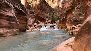
Natural Havasupai by chumley  Overview OverviewMany visitors to Havasupai never venture beyond the campground or Mooney Falls. This describes the six miles of primitive trail between Mooney Falls and the Colorado River. Warning Descending Mooney Falls is not for people with a fear of heights. The descent requires sure footing and handholds on a waterfall mist-soaked cliff while chains and slippery wooden ladders offer some protection. Further downstream there are several instances of short climbs where the tribe has installed wooden ladders. These climbs are not for everybody! Note that this hike crosses the creek eight times. There are no dry crossings, but none are more than thigh deep during normal creek flow levels.
From the end of the campground, descend down to the base of Mooney Falls using the treacherous, but well-established route. This is the most difficult part of the hike, but many are not comfortable making this descent. At the bottom of the falls, head downstream staying to the left of the creek. Follow the use path and climb the bank to the shelf above. There are a lot of paths in this area and there are no signs or indications of which one to take so you may have to explore a bit. Ultimately you will stay high and toward the cliff wall before crossing a small drainage where the trails mostly all come together into a single route to follow. A little over a quarter-mile below Mooney Falls the trail will reach the first crossing, going from the left bank to the right. Here the trail climbs steeply into the woods and away from the creek. Avoid the side trails that head back toward the creek and stay on the most "inland" route until it leads back down to Crossing 2 about a quarter mile after the first crossing. The next mile stays on the left bank and meanders through a variety of flora including huge fields of Arizona Grape. The creek isn't always in view during this stretch and after about half a mile the trail crosses a deep side drainage that features a plywood bridge that probably wouldn't pass an engineering inspection. Another half mile leads you to Crossing 3 and features remnants of an old bridge that crossed a travertine dam, but it has been destroyed and you'll have to wade across the pool above the dam. Now on the right bank, the trail is generally easy to follow and in under half a mile leads to the iconic huge palm tree that creates a tunnel of fronds for you to go under. Immediately past the palm, a ladder climbs up the adjacent cliff followed by a steep climb with steps and a couple of quick switchbacks. The next quarter of a mile traverses the cliff above Beaver Falls, featuring great views of the blue-green pools and cascades below. For those going to Beaver Falls, follow the trail to the left, descending to the creek via a few sets of ladders and steep trail cuts. (Even if your goal is to get to the Colorado, I'd recommend dropping to the creek to see the falls either on your way down or on your hike back to camp). From Mooney, the hike to Beaver Falls is about 2.5 miles and took us about 90 minutes. It can be done in less time if you ignore the views along the way, and it can take longer if you stop often or take a lot of photos. For those heading to the Colorado River, there's an unmarked trail junction above Beaver Falls. Stay high and right to get on the trail leading downstream. There's a small sign here that indicates you should not begin this route after 11am. Shortly after passing this sign you will leave the Havasupai Reservation and enter Grand Canyon National Park. This trail stays high above the creek for a quarter-mile before dropping steeply to creek level just downstream of where Beaver Canyon enters on the opposite bank. Once back in the creek, continue downstream on the right bank for a quarter-mile to Crossing 4. The trail is fairly obvious and easy to follow. Hike a little more than a quarter-mile on the left bank and you will reach Crossing 5 that takes you back to the right bank. It's nearly half a mile of traveling on the right bank before reaching Crossing 6 where you head back to the left bank. Travel on the left bank for a little bit more than a quarter of a mile and the trail will get pushed into the creek by a cliff on the left. Crossing 7 is the least obvious crossing as there doesn't seem to be a trail on the right or the left after the cliff. But in fact, the trail is on the right and will stay there until just above the confluence. Just head over there and you'll find it soon enough! About a mile downstream from Crossing 7 there's a boulder field and the route goes high above the creek to get above it before dropping back down to creek level. Three-quarters of a mile after the high boulder bypass you will pass through a little tunnel and a short downclimb to get out of it. On the other side is an area where rafters seem to congregate after hiking up from the river, with some placid pools along the creek. (There was some rock construction to create pools and direct flow while we were there, but a good flood will take care of that, so I'd hesitate to tell anybody to look for it in the future). It's a little more than a quarter-mile farther before you see the narrows that make up the last couple hundred yards of creek draining into the Colorado. You may opt for Crossing 8 to the visible trail on the left side that climbs up above the narrows and drops you down to the Colorado just below the confluence, or you may simply choose to walk through the narrows in the creek, taking you out to the scenic grotto where rafters stop and tie up their boats. The creek here isn't deep, but in the narrowest spot it did reach chest high for us, and watermarks on the rocks indicate that it may sometimes require swimming, but probably not for more than 10-15 feet of distance. That's it! You made it. Mileage-Distance-Time It should be a minimum of 6 miles from the campground to the river. It can be more depending on how many little side trips you take to check out the creek. The stats here only cover a one-way trip, though obviously most will turn around and head back the way you came. So a round-trip from camp will be a minimum 12-13 mile day and take 6-8 hours or more depending on breaks and swimming time! 9-10 hours would not be unheard of. You are hiking in some unparalleled natural beauty. Make a day of it! No Camping This is a day hike only. On the reservation, camping is limited to the campground above Mooney Falls, and in the National Park, all of Havasu Creek is restricted and camping is not permitted. Check out the Official Route and Triplogs. Leave No Trace and +Add a Triplog after your hike to support this local community. One-Way Notice This hike is listed as One-Way. When hiking several trails on a single "hike", log it with a generic name that describes the hike. Then link the trails traveled, check out the example. | ||||||||||||||||||||||||||||||||||||||||||||||||||||||||||||||||||||||||||||||||||||||||||||||||||||||||||||||||||||||||||||||||||||||||||||||||||||||||||||||||||||||||||||


