username
X
password
register
for free!
help
 This is likely a great time to hike this trail!  Check out "Preferred" months below, keep in mind this is an estimate. 
 

Pico de Teide - Tenerife Spain, WW

Guide 1 Triplog  0 Topics
  0 of 5  
Fav
Wish
0
details
drive
no permit
forecast
route  
stats
photos
triplog
topics
location
12 1 0
HAZ reminds you to respect the ruins. Please read the Archaeological Resources Protection Act of 1979 & Ruins Etiquette
Statistics
tap row or icons for details
Difficulty 5 of 5
Route Finding 2 of 5
Distance Round Trip 13 miles
Trailhead Elevation 7,700 feet
Elevation Gain 4,500 feet
Avg Time Round Trip 6-10
Kokopelli Seeds 35.5
 Interest Ruins, Historic & Peak
 Backpack Yes
 Dogs not allowed
feature photo
Photos Viewed All MineFollowing
12  2017-09-27 Booneman
Author
author avatar Guides 9
Routes 33
Photos 780
Trips 4,634 map ( 34,684 miles )
Age 44 Male Gender
Location Scottsdale, AZ
Associated Areas
list map done
Europe Region
Historical Weather
Trailhead Forecast
Radar Map
Expand Map
Preferred Apr, May, Sep, Oct
Seasons   Spring to Autumn
Sun  11:46pm - 12:25pm
Official Route
 
0 Alternative


remove free decal offer
Spain's highest peak!
by Booneman

 Likely In-Season! 
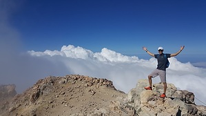
This is without question the most used and the most impressive trail in the national park. It starts out along Montaña Blanca path through pumice stone terrain for the first 3 miles. Once at the base of Mt Teide, it gives way to the old summit route that ascends Lomo Tieso over a steep gradient (about 1,000ft of gain per mile) to Refugio de Altavista or mountain hut. The path continues upwards less steeply through young black lava flows devoid of vegetation. The trail ends at La Rambleta, alongside the vantage point, Mirador de La Fortaleza.To ensure visitor safety and the preservation of the area, restrictive measures have been established, forbidding access from La Rambleta (11,656ft) to the summit (12,198ft) unless in possession of a special permit from the Teide National Park.


This trail is quite challenging, gaining 4,500 feet of elevation in 6.5 miles from the trailhead to the summit, with most of that coming in the last 3 miles. The terrain is rough in those final 3 miles as you cross steep lava fields in route to the peak

2017-10-01 Booneman


    Check out the Official Route and Triplog.

    Note
    This is a difficult hike. It would be insane to attempt this entire hike without prior experience hiking.
    Leave No Trace and +Add a Triplog after your hike to support this local community.
    WARNING! Hiking and outdoor related sports can be dangerous. Be responsible and prepare for the trip. Study the area you are entering and plan accordingly. Dress for the current and unexpected weather changes. Take plenty of water. Never go alone. Make an itinerary with your plan(s), route(s), destination(s) and expected return time. Give your itinerary to trusted family and/or friends.

     Permit $$
    None


     Directions
    or
     Road
    Paved - Car Okay

    To hike
    Montana Blanca Trailhead, Km 40 of main road TF-21 in Teide national park.
    page created by Booneman on Oct 01 2017 4:59 pm
     90+° 8am - 6pm kills
    helpcorrectionissue

    end of page marker