Route Editor

| Guide | ♦ | 3 Triplogs | 0 Topics |
details | drive | permit | forecast | route |
stats |
photos | triplogs | topics | location |
| 137 | 3 | 0 |
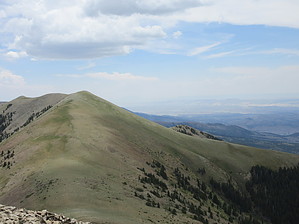
Top of the Henry's by CannondaleKid Mount Ellen ('North Summit Ridge' according to the USGS Geographic Names Information System) is located in the Mount Ellen Quadrangle in Garfield County. With a rise of 5842' from the surrounding terrain and its 11,522' elevation, it ranks #124 for the state of Utah. It is the tallest peak in the Henry Mountains and is the Garfield County high point. As such, the summit provides an awesome panorama of the area, particularly in the direction of Capitol Reef National Park to the west. The summit coordinates are: 38.108905 -110.813573. Warning Just note due to the elevation (10,500 to 11,500) you will be breathing deeper and/or faster to hike the same speed as you would at lower elevations. If you begin to get a headache, taking more and faster breaths may alleviate or at least reduce the severity.
The buffalo herd in the Henry Mountains is one of four free-roaming genetically-pure herds in North America. Note: There are three diseases of major concern to bison in Utah, brucellosis, tuberculosis & malignant catarrhal fever, and so far this herd is disease-free. (Some had brucellosis in the past but none have since 1963.) Hike The hike to the summit of Mount Ellen begins at the Bull Creek Pass trailhead, which can be reached by vehicle from three directions, north, east & west in order from easiest to hardest drive. (See directions below) Be sure to sign in at the trailhead. Not that anyone will come looking for you if you have not, but more to satisfy the curiosity of those (like myself) who like to see how far fellow hikers have traveled. The hike is pretty straightforward... just follow the reasonably well-defined trail to the summit, passing to the left of three 'summits' along the way. While the trail does not pass over these preliminary summits, if you so desire to cross them, I would recommend it on the return trip as the slopes are easier in that direction. The first half-mile or so is easy on the feet with a solid tread and since you are already at a 10,500' elevation, it provides a relatively easy warm-up for the lungs. As you approach the first saddle at about 0.7 miles, keep a sharp eye out ahead for deer, as well as buffalo on the slopes below. Off and on along the way, you will encounter several rocky areas in which you will want to pay close attention to each and every step, not of any worry for 'falling off a cliff' but just avoiding an ankle sprain or the like. The trail may become faint in a few rocky areas, but all you need to do is keep walking up along the ridge and you will make it. In similar fashion to Picketpost Mountain in Arizona, there is a summit register in a mailbox at the summit. On this occasion, the tall summit cairn was topped with an orange & black helmet with a rock in the visor. Was this a memorial of some kind? Whatever it was for, it is the most interesting find I've ever encountered on the roughly 400 summits I've reached in the last seven or so years. Again be sure to sign the summit log. If you wish to continue to Mount Ellen Peak from the Mount Ellen summit, the additional round-trip will add 1.8 miles and about 375' more AEG. Although we had planned to continue, between terrain that belied the Topo map and a slight headache we opted to skip it in favor of a 'buffalo hunt' hike along BLM 14465 on the lower western slope. Water Sources None along the trail. Camping Camping is available at two designated campgrounds: Lonesome Beaver Campground along Sawmill Basin Road (38.108898 -110.778402) McMillan Springs Campground west and below Bull Creek Pass (38.073186 -110.848241) This is BLM land, so disbursed camping is available at any spot which HAS BEEN used previously for camping. Check out the Official Route and Triplogs. Leave No Trace and +Add a Triplog after your hike to support this local community. | ||||||||||||||||||||||||||||||||||||||||||||||||||||||||||||||||||||||||||||||||||||||||