Woodland Lake Park may be the ideal outdoor area for the entire family. Facilities include tennis courts, softball fields, spacious picnic shelters, and public restrooms. Birdwatchers will find several species of waterfowl around Woodland Lake, as well as other species in the surrounding woodlands.
Woodland Lake Park has several short, interconnected trails. The 1.25-mile Lake Loop Trail is level and paved. From there, one can take a side trail to the Hitching Post Loop Trail (2 miles) or a walk to the Big Springs Environmental Study Area.
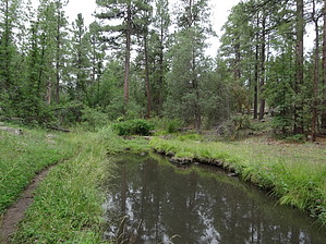
Walnut Creek Trail was first developed in 1967 as the beginning of the Lakeside District's visitor information program. It gets its name from several small springs bubbling from the east side of the creek and the black walnut trees that are part of a favorite habitat of birds and squirrels. The nature trail, once clearly established, is not as well defined today as when it was being used regularly on guided tours. Some horse trails are more clearly marked. Don't be confused, but follow the old trail until it turns left into the creek. Then follow the path downstream to the old bridge. The path leaves the canyon at this point and leads back to the point of the beginning.
WARNING! Hiking and outdoor related sports can be dangerous. Be responsible and prepare for the trip. Study the area you are entering and plan accordingly. Dress for the current and unexpected weather changes. Take plenty of water. Never go alone. Make an itinerary with your plan(s), route(s), destination(s) and expected return time. Give your itinerary to trusted family and/or friends.
 Route Editor


 Woodland Lake Park may be the ideal outdoor area for the entire family. Facilities include tennis courts, softball fields, spacious picnic shelters, and public restrooms. Birdwatchers will find several species of waterfowl around Woodland Lake, as well as other species in the surrounding woodlands.