 Route Editor

| Guide | ♦ | 22 Triplogs | 0 Topics |
details | drive | no permit | forecast | route |
stats |
photos | triplogs | topics | location |
| 410 | 22 | 0 |
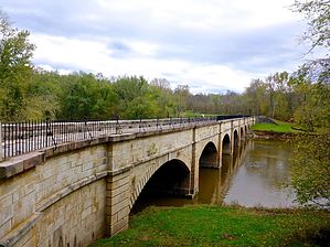
Early Interstate Highway by kingsnake  Originally conceived of by George Washington -- yes, that one -- who spent his pre-hero days surveying much of the area between the Virginia Tidewater and what is now known as PIttsburgh. In 1785, Washington's Potowmack Company began building four "skirting canals" around the Potomac River's major rapids: Little Falls, Great Falls, Seneca Falls, Payne's Falls and finally House's Falls at Harpers Ferry. The Erie Canal, in upstate New York, which began operation in 1821, began taking shipping business from locations further down the Atlantic Seaboard, prompting the construction of a full canal paralleling the Potomac River. (Sometimes the C&O Canal and the river are only yards apart, other times as much as a quarter mile.)
The C&O Canal ran 184.5 miles from Georgetown, Washington D.C. to Cumberland, Maryland. (The vast majority of the mileage is in Maryland, but as the start is in D.C., that's where I've designated the 'state'.) A planned section to connect to the Ohio River at Pittsburgh -- and thus, to the Mississippi River and the American heartland -- never got off the drawing board. The C&O Canal had 74 locks, 11 aqueducts, hundreds of culverts, and even flowed through a half mile long tunnel (the Paw Paw Tunnel, between milepost 155-156 at the Bevan Bends). The maximum length of a canal boat was 90 ft., and the maximum beam (width) was 14.5 ft., which could carry a load of over 100 tons. A typical trip from Cumberland to Georgetown was seven days, but the fastest trip was only 62 hours (with a 128 ton load). Hike Nowadays, the Chesapeake and Ohio Canal National Historical Park contains and maintains the old canal and its associated tow path. The hike, or more commonly bike, is still 184.5 basically flat miles from Georgetown to Cumberland. There are numerous access points, so section hikes & day hikes are easy. For the most part, the path is hard packed gravel & sand. It can be a bit bumpy in spots, but nothing major, though you'd probably want to avoid riding a street bike on it. The surface drains well, but it can be muddy where ruts have formed. West of Georgetown, the canal itself is now mostly dry or swampy, with many fallen trees. Views of the Potomac River are often obscured by trees, so you may need to beat brush down a muddy incline to get a better view. From personal observation on several occasions at different locations, it is almost entirely used by dog walkers, joggers, and bikers. However, there are campgrounds, and regular access to nearby towns with places to sleep & eat. (In some cases, like Hancock, the trail goes through town, in others like Sharpsburg, it may be a few miles into town.) The Appalachian Trail, between Harpers Ferry and the Weverton Cliffs, shares three miles with the C&O Canal Path. There is a lot of Civil War history nearby to the C&O Canal, particularly at Harpers Ferry and Sharpsburg. In addition, besides the canal locks, there are other interesting tidbits to check out here and there, such as the lime kiln near milepost 65. The western end of the C&O Canal Path is at the visitor center in Cumberland, where the Great Allegheny Passage begins. (The Great Allegheny Passage is a 150-mile rail trail to Fort Duquesne at the Three Rivers confluence in the middle of Pittsburgh.) Water Sources You can get water, and other supplies, from one of the nearby towns, but there are also well hand pumps every few miles. Check out the Official Route and Triplogs. Leave No Trace and +Add a Triplog after your hike to support this local community. One-Way Notice This hike is listed as One-Way. When hiking several trails on a single "hike", log it with a generic name that describes the hike. Then link the trails traveled, check out the example. | ||||||||||||||||||||||||||||||||||||||||||||||||||||||||||||||||||||||||||||||||||||||||||||||||||||||||||||||||||||||||||||||||||||||||||||||||||||||||||||||||||||||||||||||


