 Route Editor

| Guide | ♦ | 1 Triplog | 1 Topic |
details | drive | permit | forecast | 🔥 route |
stats |
photos | triplog | topic | location |
| 25 | 1 | 1 |
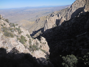
Wild and Woolly by rvcarter  Background BackgroundOur quest to hike across the Pusch Ridge between Table Mountain and Pima Saddle probably originated with hikes/scrambles to peaks above Buster Mountain in 2015 and 2016. It was from these peaks that we were treated to stunning views of Leviathan and Wilderness Domes, which are NW of the Pima Saddle. We wondered if there was a way to cross the ridge at the head of Alamo Canyon and go down the Pima Canyon Trail. With no particular plan in mind, we hiked to the base of Leviathan on November 25, 2016. Thinking there might be a better way up via Dead Horse Canyon, we tried that route on December 7, 2016. After that was a cliff out, we went back up Alamo Canyon with serious attempts on December 15, 2016 (got off to the SW and cliffed out), and December 30, 2016 (too much water in Alamo Canyon for good footing). During the last attempt, we could see the correct route to the saddle, but an additional, heavily vegetated 1000 feet of climbing was beyond my reach that day. All of these previous attempts are covered in my previous HAZ posts. It occurred to us that a crossing in the other direction (Pima to Alamo) was more realistic, due both to the easier ascent to the saddle on Pima Canyon Trail, and we could take a rope and gear to rappel any dangerous down-climb parts. So a year goes by with sheep project restrictions and summer temperatures. Finally, after a couple of trips to look down the canyon and explore the saddle, we did it.
Hike Pima Canyon Trail # 62 is well known to the Tucson hiking community and is well documented in an existing HAZ description (https://hikearizona.com/decoder.php?ZTN=1408). It extends from the Iris O. Dewhirst TH parking lot at the east end of Magee Road to its intersection with the Finger Rock Trail # 42 SSE of Mt. Kimball. (Ignore its reference to Buster Mountain, since #62 doesn’t come close to Buster.) On this hike, we cut off #62 just past Pima Spring and bushwhacked (although there is a faint trail) north to the lowest saddle along the ridgeline. If you reach the metal sign marking the turnoff to the Pima Saddle, you’ve gone too far. The real action begins at the ridge. Look the place over and decide where to begin your descent. Our route looked ok so we kicked off. We carried a 6 mm, 200-foot pull cord rated at 2200 lbs and enough gear (i.e., webbing and bale rings) to do at least five rappels. As it turned out, only one rappel was necessary, but several other pour-offs could have been handled that way. Upper Alamo Canyon is wild, super steep, and scary, but densely vegetated with good-sized trees so there are good options at critical spots for sling anchors with bale rings. Footing is loose because of the loose soil and rocks, so you had to be constantly aware of where your partner(s) were. The first 1000 feet of the descent is the most problematic, but the canyon doesn’t let up for several more miles. There are at least two other places where careful walk-arounds are needed; the difficulty increases dramatically when water is flowing in the canyon. At the time of our crossing, there were only a few shrinking pools present, none of which held fresh water. After second 1000 feet of brushy descent, the canyon devolves into an outstanding bouldering opportunity. Unfortunately, the fatigue and mental stress which have set in from work in the upper canyon makes the otherwise fun boulder hopping a time-consuming chore. You finally reach a place SW of Buster Mountain past some house-sized boulders that a trail climbs out of the canyon. Don’t miss this exit because you’ll be rewarded with more boulder hopping. By this time, the body is screaming for something easy. Nearly a mile further, you leave the Pusch Ridge Wilderness Area and enter Catalina State Park; there is a good trail for the final 1.5 miles to the Romero Ruins Trailhead. All in all, this is not a hike I would recommend. The only HAZ people I would expect to give it a try are the experienced canyoneering types. Lower Alamo Canyon to the base of Leviathan is great fun for people who enjoy boulder hopping. Above that point, it’s wild, mostly dark from the shade and canyon walls, and choked with grapevines and other brush. The upper canyon involves significant scrambling, is not very forgiving, and is labor-intensive. I’m not sure that the 1000 feet near the saddle can be safely climbed or descended, unless you’re Alex Honnold, without technical climbing gear. Wear long pants and long sleeves; gaiters, gloves, and glasses to cover your eyes are recommended. Despite the listing of January and February among the preferred months, be aware that the off-trail portions of this hike are currently restricted from January 1 thru April 30 each year because of the Bighorn Sheep Reintroduction Project. DON'T go during wet weather. Logistics As a one-way hike, you’ll need to station a vehicle at the ending trailhead, in this case, the Romero Ruins TH at Catalina State Park. The park’s entry fee, as of November 2017, is $7.00 for a vehicle with four people. Check out the Official Route and Triplog. Note This is a difficult hike. Arrive fit and prepared or this could get ugly. Leave No Trace and +Add a Triplog after your hike to support this local community. One-Way Notice This hike is listed as One-Way. When hiking several trails on a single "hike", log it with a generic name that describes the hike. Then link the trails traveled, check out the example. | |||||||||||||||||||||||||||||||||||||||||||||||||||||||||||||||||||||||||||||||||||||||||||||||||||||||||||||


