Route Editor

| Guide | ♦ | 5 Triplogs | 0 Topics |
details | drive | no permit | forecast | 🔥 route |
stats |
photos | triplogs | topics | location |
| 42 | 5 | 0 |
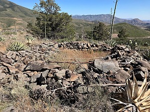
Modern and ancient sit adjacent by John10s   Overview OverviewIron Dike (5,027'), located on the west side of Highway 87 across from Mt. Ord, provides beautiful views of the Mazatzal Wilderness and is home to a multi-room hilltop ruin site that can be accessed via a round-trip hike of around two miles. While all but the most serious ruin enthusiasts probably won't find Iron Dike worthy of a dedicated trip, it makes a short and interesting stop on the way to or from many of the popular destinations further north along Highway 87. Note The official route described here starts from an unmarked dirt pullout on the north side of FR 626 near the intersection with Highway 87, then takes a direct approach at the east side of the mountain. An alternative route that avoids some of the brush and thick grass starts from a forest road (which does not appear on Google Maps) that branches off southbound 87 just north of the FR 626/Highway 87 intersection. You can park there and follow the road toward Iron Dike.
Park at the dirt pullout on the north side of FR 626 and start hiking north, aiming for the transmission towers on the east side of Iron Dike. In less than a tenth of a mile, cross a wire fence--the top wire doesn't have any barbs, so it's easy to step over. Although the terrain between the parking area and Iron Dike is mostly flat, you'll have to cross or hike around several brush-choked washes. Choose the path of least resistance, but the thick grass is unavoidable and may, depending on the time of year and dryness, leave your footwear covered with itchy souvenirs. After passing between the two transmission towers, start ascending the southeast side of the mountain. The brush gets thicker here, and you'll have to navigate several talus slopes on the steep final ascent. With the large quantity of loose rock, it's clear that there was no shortage of building materials for the ruins on top. A perimeter wall that partially surrounds the site blends in well but will come into view as you reach the top of the slope. On top of Iron Dike, you'll see that the outer defensive wall protects a long stretch of the south/southeastern portions of the ridge where the mountaintop is more accessible. There are also several well-defined interior rooms, some circular in shape, inside the perimeter wall. The origin of the ruins is unknown; they may have been built by Native Americans, but the cavalry also had a base of operations in the area in the late 1800s. The site doesn't have any artifacts, but that's not surprising given the proximity to modern civilization, with the highway and power lines nearby. In addition to the ruins, Iron Dike offers impressive views of the Mazatzals to the west, with Saddle Mountain as one particularly recognizable landmark. Mt. Ord is visible across the highway to the southeast, along with distant views of the Superstitions. Looking off the southwest side of Iron Dike, you can see several forest roads that lead to various Mazatzal trailheads. After you've enjoyed the ruins and the surroundings, you can descend and return to the parking area via the same route. Check out the Official Route and Triplogs. Leave No Trace and +Add a Triplog after your hike to support this local community. | ||||||||||||||||||||||||||||||||||||||||||||||||||||||||||||||||||||||||||||||||||||||||||||||||||