Route Editor

| Guide | ♦ | 2 Triplogs | 0 Topics |
details | drive | permit | forecast | map |
stats |
photos | triplogs | topics | location |
| 4 | 2 | 0 |
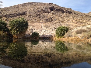
 After a very short walk from the parking area, you'll be amazed by the desert oasis created by Rogers Spring. Surrounded by California fan palms and tamarisk, the 50-feet wide pool stays at a constant 80 degrees fahrenheit. The spring produces about 1,000 gallons of water per minute. Warning While wading is allowed, a sign warns that you should not submerge your head in the water. Naegleria fowleri, a parasitic amoeba, may be present in the water and will enter your body via your nose.
According to the National Park Service website..."Rogers Spring and other springs in the “North Shore Complex” comprise one of the terminal discharge areas for the regional carbonate-rock aquifer system of eastern Nevada and western Utah. The source of the water to this spring and other regional carbonate-rock aquifer springs is uncertain. The prevailing theory suggests that much of the recharge water that enters the carbonate-rock aquifer occurs in the high mountain ranges around Ely, Nevada, located 250 miles north of Lake Mead. As this ground water flows south through the carbonate rocks, it encounters several faults along the way, including the Rogers Spring Fault, which has caused the older carbonate rocks (primarily limestone and dolomite) to be displaced against younger evaporite deposits of the Muddy Creek and Horse Spring formations. Here, the lower permeability of these evaporite deposits, along with high subsurface water pressure, forces the ground water in the carbonate rocks to flow upward along the fault and emerge at the surface as Rogers Spring. Rogers Spring and Blue Point Spring both share a colorful history. One story involves a 1903 project to build a canal to divert water from both springs to 500 acres of farmland located several miles south of St. Thomas. During this effort, several industrious men used a horse team, scraper, homemade ditcher and shovels to construct a channel to connect both springs. They tested the channel and discovered that the water flowed only a short distance before soaking in. Undaunted, they lined the ditch with clay to prevent leakage, and when that failed, they borrowed $3,000 and took several months mixing cement by hand and again lining the ditch. Eventually, they were successful in transporting the water to the intended land. However, the project ultimately failed due to economic reasons. The men involved evidently drank the spring water while working on the project. Unfortunately, this water acted as a natural laxative, and these individuals lost a considerable amount of weight. Subsequently, the channel discharging water from Blue Point Spring became known as “Slim Creek.” Several other projects have been attempted in association with Rogers Spring and Blue Point Spring, including a water fowl refuge construction project that was initiated from 1938 through 1943 but never completed, and a tropical fish hatchery that operated at Blue Point Spring during the mid 1950s." Hike The walk to the pool and creek is very short and is on a paved walkway suitable for wheelchairs. The pool can be viewed from a few sites where the palm trees and invasive tamarisk are not growing. Hundreds of small fish live in the pool (including species that we suspect might have previously lived in an aquarium!). Picnic tables and grills are available as are vault toilets. We did not view the springs as worthy of a journey in and of itself, but rather as something unique to see while in the area. Check out the Triplogs. Leave No Trace and +Add a Triplog after your walk/tour to support this local community. | ||||||||||||||||||||||||||||||||||||||||||||||||||||||||||||||||||||||||||