Pico de Orizaba - South Route, PV • Hike & Climb Trip


Pico de Orizaba - South Route, PV

Guide 1 Triplog Mine 0 0 Topics
 
0 of 5 
Fav
Wish
0
details
drive
no permit
forecast
route  
stats
photos
triplog
topics
location
11 1 0
Warning! Technical climbing skills required. Risks include serious injury to death.  Risks are not eliminated by skill.
Climb Consensus (1) → View
Difficulty
Climb
Rock
Length
Statistics
tap icons for details
Difficulty 5 of 5
Route Finding 3 of 5
Distance Round Trip 2.5 miles
Trailhead Elevation 15,045 feet
Elevation Gain 2,786 feet
Accumulated Gain 2,786 feet
Avg Time Round Trip 8-10 hours
Kokopelli Seeds 16.43
 Interest Off-Trail Hiking & Peak
 Backpack Yes
 Dogs not allowed
feature photo
Photos Viewed All MineFollowing
Inaugural Calculation on Button Tap!
11  2018-01-25 Booneman
Author
author avatar Guides 9
Routes 33
Photos 736
Trips 3,990 map ( 30,685 miles )
Age 42 Male Gender
Location Chandler, AZ
Historical Weather
Trailhead Forecast
Radar Map
Expand Map
Preferred Nov, Dec, Jan, Feb → 3 AM
Sun  5:49am - 5:35pm
Official Route
 
0 Alternative
 
 Water
Nearby Area Water
[ View More! ]
no photo labels yet
+Add > Photos to this Guide
then label as applicable
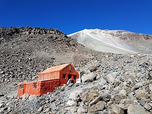
Highest Mountain in Mexico!
by Booneman

 
Pico de Orizaba (Citlaltepetl or Star Mountain) is the highest mountain in Mexico and the third tallest peak in North America. There is much debate about the actual height of the summit, though it is believed to be close to 18,500ft. Orizaba is one of only three Mexican peaks that support glaciers, and is a huge stratovolcano that is currently dormant with the last eruption recorded in the 19th century. Located East of Mexico City, approximately 120 miles, Orizaba straddles the Central Mexican states of Puebla and Veracruz which can both be seen on a clear day.
The normal or standard route approaches from the North, as the 2000ft Jamapa Glacier is the fastest way to climb the peak. If conditions are not ideal on the North side, this Southern route can be accessed through the national park near Sierra Negra mountain past the city of Serdan. There isn't much of a trail, it's more like following a ridgeline and finding the best footing up the volcanic scree fields. Intermittent cairns will help guide the way, but if an alpine start is part of your plan, it's a good idea to study the route prior to climbing.

The end of the four wheel drive access road (15,000ft) will serve as a trailhead and get you close to the Fausto Gonzales Hut (15,500ft), where you can start the hike or stay the night (or camp nearby) with no permit required. From this point the climbing begins, ascending off trail through the boulder field to the steep scree all the way to the summit.

There are a few routes to the summit, most requiring technical equipment (crampons, ice axe, rope, etc.), though the south route typically does not during the dry season (December-January). However, a helmet, trekking poles and ice axe and crampons are always a wise choice for any mountaineering endeavor.

Good luck.

Check out the Official Route and Triplog.

Leave No Trace and +Add a Triplog after your hike & climb trip to support this local community.

2018-02-03 Booneman
    WARNING! Hiking and outdoor related sports can be dangerous. Be responsible and prepare for the trip. Study the area you are entering and plan accordingly. Dress for the current and unexpected weather changes. Take plenty of water. Never go alone. Make an itinerary with your plan(s), route(s), destination(s) and expected return time. Give your itinerary to trusted family and/or friends.

     Permit $$
    None


     Directions
    or
    or
     Road
    Strictly 4x4

    To hike & climb trip
    Many options exist based on your travel plans and/or comfort level. You can hire a driver or navigate the bus system to the town of Tlachichuca. From there, you will want to contact one of three outfitters (Summitorizaba, Servimont or Orizaba Mountain Guides for 4x4 transportation to either trailhead).
    page created by Booneman on Feb 03 2018 11:18 am
    helpcorrectionissue

    end of page marker