 Route Editor

| Guide | ♦ | 2 Triplogs | 0 Topics |
details | drive | no permit | forecast | route |
stats |
photos | triplogs | topics | location |
| 28 | 2 | 0 |
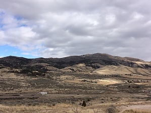
Shortest distance to the top by Woodsnative There are many options for getting to the top of Chinese Peak and many options for looping back down on another trail. This trail is the shortest and fastest for hiking. Each of the numbered trails are graded roads, which are open to motorcycles, off-road vehicles, bikes, cars, trucks, and so on, between the dates of April 15 and November 15. The gates are closed for vehicles and mechanized travel in the winter season. History Chinese Peak was named for a Chinese man who died near the summit in the 1890s. It is the highest peak within the Pocatello Range, which is a small sub-set of peaks within the Portneuf Range. The Portneuf range goes north to south for approximately 60 miles between Blackfoot / Pocatello on the north, and Preston on the south. Chinese Peak had a fire lookout from the 1960s up until 2003. It currently has 5 or 6 radio, satellite, and TV tower stations, each with a small building and some with a fence. If you take a quick look at the satellite pictures, it looks like a small neighborhood got placed right along the ridge.
The trails to Chinese Peak are probably best for a quick hill climb or bike ride that is close to home and are not the most scenic. The lower parts of the trail have yellow grass, which then becomes mixed with junipers and in some places, sagebrush. Near the top are scrub oak and thicker stands of trees. This trail is on the west slope, so it is much dryer and less green than the east slopes. Gate Policy: If a gate is closed upon arrival, leave it closed after you go through. If it is open, leave it open. Leaving a closed gate open may put cattle in danger. Closing an open gate may cut them off from water. Please be respectful, leave gates as found. The exception is signage on the gate directing you otherwise. Check out the Official Route and Triplogs. Leave No Trace and +Add a Triplog after your hike to support this local community. One-Way Notice This hike is listed as One-Way. When hiking several trails on a single "hike", log it with a generic name that describes the hike. Then link the trails traveled, check out the example. | ||||||||||||||||||||||||||||||||||||||||||||||||||||||||||||||||||||||||||||||||||


