Route Editor

| Guide | ♦ | 1 Triplog | 0 Topics |
details | drive | permit | forecast | map |
stats |
photos | triplog | topics | location |
| 17 | 1 | 0 |
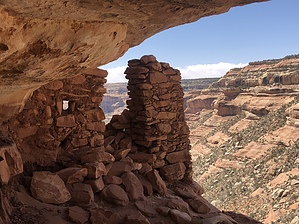
Life On The Edge by AZLOT69  A well established but unmarked trail starts off along the fence line. It soon comes to slick and smooth pink sandstone. There are many social trails but try to follow the main route following cairns. The idea here is to make a wide backward C pattern off to the right crossing the pink sandstone and coming to a V at the edge of the sandstone.
Looking across the way look in the narrow crevices along the bench to see ruins. Many may stop here. If you are up to it look over the edge and left to see a very narrow ramp going down with a juniper tree growing out of the crack. This will be your only real handhold. Carefully working your way down to this next bench. The trail is pretty obvious now off to the left and very quickly you come to the first ruin with an information, sign in box from the forest service. Rules and some history are also included. Slowly work your way around the bench, past a dripping spring with hanging garden, more ruins, several more ruins, and a great Kiva. Many times you are only feet or inches from the edge. Not for the faint. Had your fill ? Return the way you came. Check out the Triplog. Leave No Trace and +Add a Triplog after your hike to support this local community. | ||||||||||||||||||||||||||||||||||||||||||||||||||||||||||||||||||||||||||||||||||||||