Route Editor

| Guide | ♦ | 4 Triplogs | 0 Topics |
details | drive | no permit | forecast | 🔥 route |
stats |
photos | triplogs | topics | location |
| 56 | 4 | 0 |
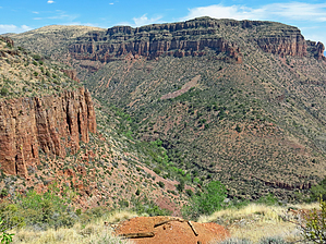
  This scenic and historic 1950's Uranium Mining Adits area and Camp bordering the southern Sierra Ancha Wilderness, is a very interesting area to meander around. In my opinion, the scenic Sue Uranium Mines Road with viewable, large open Adits is worth the visit alone (views along this short mining road of the rugged Sierra Ancha "Lower Deep Creek and Bull Canyon" confluence area is exceptional!) This scenic and historic 1950's Uranium Mining Adits area and Camp bordering the southern Sierra Ancha Wilderness, is a very interesting area to meander around. In my opinion, the scenic Sue Uranium Mines Road with viewable, large open Adits is worth the visit alone (views along this short mining road of the rugged Sierra Ancha "Lower Deep Creek and Bull Canyon" confluence area is exceptional!)It is recommended to download and follow the posted "official" Gps Route for this out and back hike.
(MINERAL INVESTIGATION OF THE SIERRA ANCHA WILDERNESS AND SALOME STUDY AREA, GILA COUNTY, ARIZONA 1985) Sue Mine "The Sue Mine is located on the south side of Bull Canyon, in the SW 1/4 sec. 19, T. 5 N., R. 15 E. (unsurveyed), approximately 1/2 mile south of the wilderness (plate i). The mine is accessible by about 1/2 mile of an old road which starts near the top of the Bull Canyon road. The Sue claims were staked in 1954 by K. C. Heron for Arizona Globe Uranium, Inc. Total workings on the property amount to about 1,700 feet of drifts and crosscuts that connect two adits that bear S. 20 ° W. (figure 43). A third adit, started to the west of the main workings, extends 30 feet. Approximately 750 feet of the workings were financed by a Defense Minerals Exploration Administration grant (Granger and Raup, 1969a, p. 129). Ore produced from the Sue Mine totaled 450 tons averaging 0.21 percent U308 (Schwartz, 1957, p. 56). In 1978 the claims were held by a joint venture agreement between Wyoming Minerals Corp. and B and B Mining Co." Check out the Official Route and Triplogs. Leave No Trace and +Add a Triplog after your hike to support this local community. | |||||||||||||||||||||||||||||||||||||||||||||||||||||||||||||||||||||||||||||||||||||||||||||||||||||||