Route Editor

| Guide | ♦ | 1 Triplog | 0 Topics |
details | drive | no permit | forecast | 🔥 route |
stats |
photos | triplog | topics | location |
| 35 | 1 | 0 |
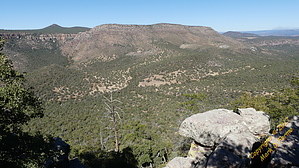
No flat cows here by CannondaleKid   Overview OverviewCow Flat Mountain is located in the McFadden Peak Quadrangle in Gila County, overlooking upper Cherry Creek. With a rise of 546' and 'stated elevation' of 5,766,' its 'Arizona Prominence Rank' is 2065. (According to the latest information from Gila County, the current actual elevation is 5,751. The highest elevation I observed was 5748.) Coordinates: 33.9844902 -110.9178988 Official GPS Track The official GPS route is edited to use the best of our ascent and descent routes. It does not include our additional wandering farther north to Cow Flat Tank, which if you were to continue, the old road leads quite some distance up to another tank on the NW slope of Cow Flat Mountain. (Another option when you return to the TH is to head directly west on a faint old mining road and do some exploring of old mining structures and artifacts.
Nothing out of the ordinary when hiking on rocky roads or off-trail through some thicker areas of vegetation. History It appears the only things of note are cattle grazing on Cow Flat and a few mining claims within a mile to the SW. Hike Parking is available where the old Jeep trail leaves FR 329 at 33.97622 -110.92932, which is about 3.5 miles from Young Highway/Board Tree Saddle via FR 203 & FR 329. (Just past Ash Creek Spring.) The hike begins along an old road, which is still used by the grazing leaseholder. Just over a quarter-mile in you will cross Ash Creek, which empties into Cherry Creek just over 2 miles downstream. Once across the creek, you will climb about 400 feet over the next half-mile, at which time the grade eases and you simply continue another half-mile along the road. When you reach the 'Leave Road' waypoint at 33.99180896 -110.9236763 you turn 90° right and follow the route about 0.6 miles up to the saddle. At the saddle, you make another 90° right turn and work your way the last quarter-mile to the summit. While there are a few great views westward from the summit, they are limited by the trees. For the best view east over upper Cherry Creek, if you DON'T want to spend a half-mile round-trip bush-whacking eastward, take a short detour from the saddle to the viewpoint on the return leg. Water Sources There was flowing water out of a pipe at the concrete tank adjacent to the trailhead, which is fed from Ash Creek Spring. It appears this is perennial so it's likely a reasonably reliable water source. While it was dry in November 2017, there MAY be water flow in Ash Creek in the creek, but it cannot be relied upon. Cow Flat Tank was reasonably full when we visited it, but again, it cannot be relied upon. Note: Filtering will be required! Camping There are a few dispersed camping sites within a mile along Forest Road 329, which is where we camped overnight. Check out the Official Route and Triplog. Leave No Trace and +Add a Triplog after your hike to support this local community. | |||||||||||||||||||||||||||||||||||||||||||||||||||||||||||||||||||||||||||||||||||||||||||||||||||||