Route Editor

| Guide | ♦ | 1 Triplog | 0 Topics |
details | drive | permit | forecast | route |
stats |
photos | triplog | topics | location |
| 24 | 1 | 0 |
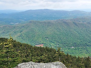
No mountain for old men by DixieFlyer This guide describes hiking to the summit of Calloway Peak, the highpoint of Grandfather Mountain, via the Profile Trail. Grandfather Mountain is in western North Carolina, about 70 miles northeast of Asheville and 15 miles southwest of Boone. Calloway Peak is at an elevation of 5,946 feet and it has a prominence of 2,445 feet. Grandfather Mountain is the highpoint of two North Carolina counties: Watauga County and Caldwell County. History Grandfather Mountain is part of the Appalachian Mountain chain, which dates back to 1.1 billion years ago. These mountains today are a product of two things: mountain building that culminated 300 million years ago and erosion that has been ongoing for 100 million years and continues to this day. It is said that these mountains were once 10X higher than they are today.
Early explorers of Grandfather Mountain include Daniel Boone, who hunted in the area in the 1760s. French botanist Andre Michaux climbed Grandfather in August of 1794 and wrote: “I reached the summit of the highest mountain in all of North America, and with my companion and guide, sang the Marseillaise and shouted ‘Long live America and the Republic of France, long live liberty!’” While Señor Michaux may have been a bit over-zealous in his elevation calculations, his enthusiasm for Grandfather Mountain is quite understandable! Naturalist John Muir visited Grandfather in September 1898. Muir had been ill with a bronchial cough for many months, but after climbing Grandfather he wrote to his wife, “the air has healed me. I think I could walk ten miles and not be tired.” According to an article in the American Museum Journal, he fell into poetic raptures over the view from the top, saying, “I couldn’t hold in, and began to jump about and sing and glory in it all.” source: History of Grandfather Mountain. Red Tape There is no fee to park at the Profile Trailhead or to hike on the Grandfather Mountain State Park trails from this access point. However, you do need a permit, which is free and available at the trailhead. You fill out the permit and keep one copy with you and put the other copy in a box at the trailhead. The state park is open from 8:00 AM to 8:00 PM. Overview The hike begins at the Profile Trailhead on the west side of Grandfather Mountain in the State Park. From the trailhead, you'll hike on the Profile Trail for 3.5 miles to Calloway Gap, where the Profile Trail ends at the Grandfather Mountain Trail. From Calloway Gap, take the Grandfather Mountain Trail for 0.4 miles to the summit of Calloway Peak. Then return to the trailhead the way that you came. The lower part of the hike is mainly under a thick canopy of deciduous hardwoods with rhododendron thickets. As you gain elevation, there is a transition to a red spruce and Fraser fir forest. Along the way is a "forest" of huge boulders alongside the trail. Hike As mentioned above, you'll begin by hiking for 3.5 miles on the Profile Trail. The trail is well-marked and is easy to follow. There are some ups and downs for the first 1.5 miles, which result in little if any, net elevation gain. However, as you continue there is a steady gain in elevation. The trail becomes more rocky, with some exposed tree roots in places. At the 3.2-mile mark, you'll see a sign marking Shanty Spring, which is the last sure water source on the hike. From Shanty Spring it is another 0.3 miles to the end of the Profile Trail at Calloway Gap. Some natural rock stair steps in this section make the going a little slow. Once at Calloway Gap, you will have a gross elevation gain of around 2,100 feet. From Calloway Gap, make a left turn on the Grandfather Mountain Trail. From here it is 0.4 miles with about 300 feet of elevation gain to the Calloway Peak highpoint. The trail is somewhat rocky and not quite as easy to follow as the Profile Trail was. Just before the highpoint, you'll see a sign saying "Watauga View 100 feet". There are some nice views here, so it is worth checking out. Plus the viewpoint is the highpoint of Watauga County. As you make your way to the Calloway Peak highpoint, there are 3 wooden ladders affixed to rock slabs that help navigate some rock outcroppings. Two of the ladders have 4 rungs and the other has 3 rungs. There will be some class 2 rock scrambling involved, although there is no exposure to speak of. Once atop Calloway Peak, you will be at the top of Grandfather Mountain and the Caldwell County highpoint. Return on the Grandfather Mountain Trail to the Profile Trail at Calloway Gap, and then take the Profile Trail back to the trailhead. From Calloway Gap, it is 1.9 miles on the Grandfather Mountain Trail to the famous "Mile High Swinging Bridge", which is a popular tourist attraction. Before going back to the Profile trailhead, fit and adventurous hikers might wish to first hike to the swinging bridge and back from Calloway Gap. However, note that there will be about 1,800 feet of elevation gain on the way back to Calloway Gap from the Swinging Bridge. Other Routes to Calloway Peak In addition to taking the Profile Trail from the west side, there are 2 other popular routes to the top of Grandfather Mountain: 1) The Daniel Boone Scout Trail from the east side that starts off of the Blue Ridge Parkway 2) The Grandfather Mountain trail from the southwest that starts at the Swinging Bridge The Daniel Boone Scout Trail is a little shorter and easier than taking the Profile Trail. Like the Profile Trail, there is no fee involved. Starting from the Swinging Bridge involves a fee of $20-$30 per person, depending on whether or not you go at a peak time. This trail is a more challenging trail than either the Profile Trail or the Daniel Boone Scout Trail. Water Sources There are some creek crossings in the lower part of the Profile Trail where water is available year-round. At higher elevations, water availability is seasonal. Camping There is a camping fee, and camping is allowed only in designated camping areas. Check with the Grandfather Mountain State Park for details.
Check out the Official Route and Triplog. Leave No Trace and +Add a Triplog after your hike to support this local community. | |||||||||||||||||||||||||||||||||||||||||||||||||||||||||||||||||||||||||||||||||||||||||||||