Route Editor

| Guide | ♦ | 27 Triplogs | 0 Topics |
details | drive | permit | forecast | route |
stats |
photos | triplogs | topics | location |
| 253 | 27 | 0 |
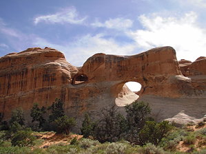
No Hail Mary's required by nonot  The Primitive Loop has many spur options found at the northwest corner of Arches National Park. Warning Devil's Garden is a desert hike and can take several hours so bring plenty of water. If it rains, the east half of this trail could be difficult due to climbing sections of slickrock slopes, which you wouldn't want to do when wet.
Drive to the trailhead and park in one area of the immense lots. From the restrooms and trail signs, there is only one entrance path. The first third of a mile or so is mostly paved for wheelchair access and leads to Landscape Arch. Only 1000 feet in, there is a short trail on your right. Take this to look at Pine Tree Arch and Tunnel Arch. Return to the main trail and admire Landscape Arch. That's the easy part, and you could return to your car, having hiked less than a mile total. However, since you've gone this far, you'll probably want to take the primitive trail that adds a little over 4 miles, growing to about 7 if you exercise all the spur options. Assuming from Landscape Arch, you continue a steep hike/climb north at the primitive trail sign. You will be making the loop clockwise as follows. After a thousand feet, a spur branches off the west. Take the spur, and it splits again. The first spur to your left goes to Partition Arch, the other to Navajo Arch, each are about 800 feet each way. Return to the primitive trail. Continue climbing, follow the ridge of slickrock. Where you get cliffed out, look for some carved out steps in the slickrock below you on the west side. After about a mile of hiking, you will reach the Double O Arch area. It is located over the ridge to your west. Descend through the ridge on the cairned path. From this point, you can also take the spur trail directly to the base of double o arches and further on to dark angel rock, a blackened hoodoo about a third of a mile each way. Return to the primitive trail. Continue north through the boulders until you notice the top story window through a fin to your north. Here you will see a signed spur for Fragile Arch, which goes southeast for about 1200 feet each way. Return to the primitive loop trail. Continue northeast and then southeast. This is by far the most challenging section as there are some steep climbs over some slickrock slopes. Finally, you will reach the sandy area and slog around the rest of the loop another 2 miles until you arrive back at Landscape Arch. Return the mostly paved path southeast to your car Exercising all of the spurs will net you 8 miles total. Besides the sand, the hiking is relatively easy, although you may have trouble in sections if you have an extreme fear of heights. Water sources none, except for some muddy spots Camping none allowed in Arches Check out the Official Route and Triplogs. Leave No Trace and +Add a Triplog after your hike to support this local community. | ||||||||||||||||||||||||||||||||||||||||||||||||||||||||||||||||||||||||||||||||||||||||||||||||||||||||||||||||||||||||||||||||||||||||||||||||||||||||||||||||||||||||||||||||||