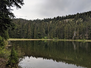
This trail enters the west side of the Badger Creek Wilderness and is a short and easy hike to a beautiful alpine lake. This trail descends for 0.3 mile to Jean Lake at a moderate grade. When the trail reaches the lake, the trail forks and loops around the lake. The trail can be faint on the east end. Jean Lake is a relatively small three acre, shallow lake. Access is difficult to find and signage is limited. Users need to pay attention to map directions as the trail is difficult to locate.
When hiking several trails on a single "hike", log it with a generic name that describes the hike. Then link the trails traveled, check out the example.
WARNING! Hiking and outdoor related sports can be dangerous. Be responsible and prepare for the trip. Study the area you are entering and plan accordingly. Dress for the current and unexpected weather changes. Take plenty of water. Never go alone. Make an itinerary with your plan(s), route(s), destination(s) and expected return time. Give your itinerary to trusted family and/or friends.
To hike From Hood River, OR take OR Hwy 35 south 26 miles, approximately 0.15 mile past milepost 71, to Dufur Mill Road (Forest Road 44). Turn left (east) on Dufur Mill Road and drive east approximately 3.7 miles to Forest Road 4410. Turn right (south) on Forest Road 4410 and travel approximately 4.7 miles south to Bennett Pass Road (Forest Road 3550). Turn right onto Bennett Pass Road and travel 4.5 miles south to the trailhead on the east side of the road.
page created by joebartels on Jun 21 2018 11:56 am
 Route Editor


