 Route Editor

| Guide | ♦ | 5 Triplogs | 0 Topics |
details | drive | no permit | forecast | route |
stats |
photos | triplogs | topics | location |
| 15 | 5 | 0 |
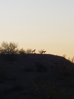
Little used stock trail/nature walk by KingLeonidas  Note NotePreserved on HAZ for historical reference. Laveen Trail is now part of Ma Ha Tuak Perimeter Trail. Intro Explored a poorly documented trail in South Mountain as a night hike with my girlfriend. The trail, which may be called Laveen Trail or East Laveen Trail, starts in Laveen (on south 28th ave) and runs to the San Juan trailhead. There are connections to several other streets along the way.
Hike The first part of the trail was wide, it may have been a jeep trail at one point but it eventually narrowed down to a very thin and sometimes faint trail. Navigation was moderately challenging given we had never hiked the trail before. There were several spots where we started down one of the access trails by accident and had to backtrack. Some of the junctions had cairns but the cairns that existed tended to be small or indistinct. The trail was fairly rough with chossy sections appearing frequently. It was not very steep and did not have a definite incline in either direction. There was enough AET from the roundtrip for the trail to be considered of moderate difficulty. It was apparent that the trail is frequently used for stock (mules) as there were lots of tracks and droppings left behind. Despite the many access points the trail did not appear to be frequently trafficked, we did not see another soul the entire time we were hiking. The real highlight of the trail was the nature aspect. There was an unusual amount of fauna in evidence. Almost immediately after starting the hike, 3 coyotes crossed the trail about 100’ ahead of us. Later on, a bat flew very slowly and close overhead. We also heard but did not see an owl of some kind. The wildlife was the highlight of the hike. The views were marginal as far as South Mountain hikes go. Some hills obstruct the view of Phoenix on the western half of the trail and the eastern half is too low to be a good vantage point. An infrequently used trail that may provide a rarer animal encounter but otherwise not a very interesting trail. Gps routes for this trail were uploaded (one for each direction) Check out the Official Route and Triplogs. Leave No Trace and +Add a Triplog after your hike to support this local community. One-Way Notice This hike is listed as One-Way. When hiking several trails on a single "hike", log it with a generic name that describes the hike. Then link the trails traveled, check out the example. | ||||||||||||||||||||||||||||||||||||||||||||||||||||||||||||||||||||||||||||||||||


