 Route Editor

| Guide | ♦ | 24 Triplogs | 0 Topics |
details | drive | no permit | forecast | route |
stats |
photos | triplogs | topics | location |
| 112 | 24 | 0 |
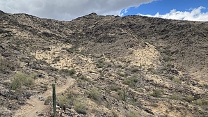
ua au u decide by LindaAnn  Overview: Easy trail along the base of the north side of the Ma Ha Tuak range of South Mountain Park. While the trail can be hiked in either direction, this guide describes it from east to west. Most people likely only hike a small portion of this trail to combine it with other trails in the area; if you plan on hiking the full length, make sure to account for how you will get back to your vehicle, as that will involve additional miles. Overview: Easy trail along the base of the north side of the Ma Ha Tuak range of South Mountain Park. While the trail can be hiked in either direction, this guide describes it from east to west. Most people likely only hike a small portion of this trail to combine it with other trails in the area; if you plan on hiking the full length, make sure to account for how you will get back to your vehicle, as that will involve additional miles.Hike: The Ma Ha Tuak Perimeter Trail begins at the 19th Ave North Trailhead. The start of the trail is immediately west of the handicap parking spaces at the northwest side of the parking lot, and is well signed. As you head west, the mountains rise to your left, while there are residences and the city to your right. The trail is in good condition, and a pleasant walk. The eastern half of the trail has more elevation change than the western half as you cross small drainages and traverse the north base of the mountain.
While the trail is well signed, there is one junction just past four miles that is unsigned and somewhat confusing. At this point, the trail has pretty much leveled off, and you can see San Juan Lookout to your southwest. Several trails meet here, but there are no signs. To stay on the Ma Ha Tuak Perimeter Trail, you'll actually want to stay right and head northwest and around the north side of a small hill. The trail will continue around the north side of these small hills as you head west. Eventually, you'll see the Loop-202 freeway ahead of you as the trail winds completely around the hills next to the freeway. At the far west end of the trail, while you are above the freeway, the trail curves south paralleling the freeway, then eventually curves east. At this point, you will be on the Maricopa Trail for a short period of time while you head east. The end of the trail is somewhat anticlimactic; it simply ends where the trail crosses the paved San Juan Road and connects to National Trail on the other side. If you've made it this far, you likely have a plan for how to get back to your vehicle, and there are several options. The fastest option is to head north on National for half a mile to San Juan Lookout, then northeast from the lookout to reconnect to Ma Ha Tuak Perimeter to make a lollipop loop. For those looking for more elevation gain and are more familiar with the area, you can head north on National Trail to San Juan Lookout, then take Alta Trail east to connect to Hau'Pal and take that back down to the trailhead.
Check out the Official Route and Triplogs. Leave No Trace and +Add a Triplog after your hike to support this local community. One-Way Notice This hike is listed as One-Way. When hiking several trails on a single "hike", log it with a generic name that describes the hike. Then link the trails traveled, check out the example. | |||||||||||||||||||||||||||||||||||||||||||||||||||||||||||||||||||||||||||||||||||||||||||||||||||||||||||||||||||||||||||||||||||||||||||||||||||||||||||||||||||||||||||||||||||||


