| Guide | ♦ | 1 Triplog | 0 Topics |
details | drive | permit | forecast | route |
stats |
photos | triplog | topics | location |
| 0 | 1 | 0 |
bring on the settlers by HAZ_Hikebot The Santiam Wagon Road holds an interesting and unique place in Oregon’s history. Unlike other wagon roads that were built to bring settlers to the Willamette Valley, this road was designed to lead settlers and their livestock eastward to the rich pasture lands of Central Oregon and to markets throughout eastern Oregon and Idaho. It was a distance of almost 400 miles and served as the primary means of transportation across the central Cascade Mountains for most of the 74 years (1865-1939) it was in use. The road served as a livestock, freight and stage route facilitating trade, commerce, and communication, which significantly contributed to the economic enhancement and settlement of both regions. Remnants of the Santiam Wagon Road have been preserved in the Willamette and Deschutes National Forests and provide the longest stretches (with very high integrity) of any historic wagon road in western Oregon.
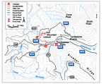
Fish Lake Section On this segment you experience an intact portion of Old Santiam Wagon Road that passes through mature forests in the Hackleman Creek area. Fish Lake Guard Station was major stopover for early travelers on the wagon road. It also played a dominant role in the early days of Forest Service management of the area. Length: 2.2 miles Elevation gain: 3100-3200 feet Latitude: 44.41330130720307 Longitude:-122.045439056504 Hackleman Section This developed route along the historic Santiam Wagon Road uses existing forest roads that tie back into the original wagon road location east of Lost Prairie Campground. This portion offers the most manageable terrain for vintage vehicles and wagons and includes terrific views of Three Fingered Jack and the Old Cascades to the north. This trail crosses US Highway 20 at two locations. This section can also be accessed by the Tombstone Pass/ Cone Peak Trailhead (Fee site). Length: 6.5 miles Elevation gain: 3200-4200 feet Latitude: 44.4020746 Longitude: -122.0845649 Mountain House Section This is the trail for accessing the Santiam Wagon Road from the farthest western end and is probably the most intact piece of the original Santiam Wagon Road, this segment will provide you with a true sense of early travel. The road parallels the South Santiam River and winds through lush old growth forests and crosses Elk Creek and several other tributaries to the South Santiam River along the way. Look for the old mill pond now grown in with red alder. Sevenmile Section A mixture of dense second-growth and patches of old growth forest shrouds you while you traverse the side slope of Sevenmile Hill. The eastern half of the trail follows the original route of the historic Santiam Wagon Road. This segment was immortalized in stories of the first transcontinental auto race in 1905, when trees were attached to vehicles to slow their descent of Sevenmile Hill. The trailhead can also be used to access the Snow Creek Trail section of the Santiam Wagon Road. Snow Creek Section This moderate to easy trail section, along former segments of the historic Santiam Wagon Road and newer spur roads, mixes the present with the past. Young conifer forests dominate the setting as the trail ascends to Tombstone Pass. You will be rewarded with occasional views of Iron Mountain and Green Mountain. Mountain bikers may be especially attracted to this segment as other logging roads shoot off Santiam Wagon Road toward the north and south. Check out the Official Route and Triplog. Note This is a moderately difficult hike. Leave No Trace and +Add a Triplog after your hike to support this local community. One-Way Notice This hike is listed as One-Way. When hiking several trails on a single "hike", log it with a generic name that describes the hike. Then link the trails traveled, check out the example. | ||||||||||||||||||||||||||||||||||||||||||||||||||||||||||||||||||||||
 Route Editor


