Route Editor

| Guide | ♦ | 10 Triplogs | 0 Topics |
details | drive | no permit | forecast | 🔥 route |
stats |
photos | triplogs | topics | location |
| 283 | 10 | 0 |
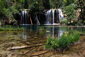
Hanging on the edge of a dream by nonot  This is a creekside hike up to a lake with several waterfalls. It is right in the heart of the Glenwood Canyon area along I70. Warning The trail is steep and could possibly get slippery when wet or in snow. During winter I imagine it would be quite icy. Bring more than a 16oz bottle of water as you'll want to take a few hours to enjoy your hike.
Glenwood Canyon is a scenic area where the Colorado River cut its way deep through the Colorado bedrock. The canyon is several hundred feet high and stunningly beautiful. The Interstate system was slated to go right through the canyon, but it took over half a century to plan, design, and build the interstate through this canyon that would co-exist with the riparian area and still provide for recreational activities. There are numerous signs and 4 rest areas in this ~10 mile section of interstate that all have commemorative plaques that detail the history of construction. The area has bike and running trails and appears to be a quite popular destination for runners, bikers, and tourists. Hike From the Hanging Lake Rest Area, begin hiking east on the paved trail about 0.5 miles until you get to the signed turnoff for Hanging Lake Trail to your northwest. Begin climbing up the rocks (this is basically the trail all the way to the top.) The trail is steep, rocky, and runs next to a gorgeous creek that cascades down from above. The snow-melt and springs that feed this creek keep the air temperature 20 degrees lower when you are within 30 feet of the water under the trees. The trail is rarely more than about 10 feet from the creek. It's magnificent! Continue jumping and high stepping your way up the boulders. There are signs every 0.25 miles to show you your progress. As you contour beneath the trees you will cross over several well constructed wood bridges and alternate on sides of the creek. Along the way you will pass a signed turn off for dead horse point. I know nothing of this trail but I was told it is longer and steep. Staying on the hanging lake trail, soon you will reach an area where the creek cascades down a mossy wall from a hundred feet above. The trail makes a U-turn and begins climbing stairs with a railing installed. The railing has taken some abuse over the years so don't trust your life to it! After a turn and a few more stairs you will emerge onto a boardwalk area and look upon Hanging Lake. There are a few benches built into the boardwalk if you want to rest. Walk around and admire the waterfalls that cascade down into the crystal clear lake. You can observe trout 30 feet away 10 feet down as if they are floating in air. The water is simply that clear! Travertine coated cliffs sparkle with the water and from above you can glimpse through the trees an enormous waterfall two hundred feet above you. Walk back to where the boardwalk began. Look away from the boardwalk up the hill and notice there is a sign for "Spouting Rock". Walk up the steep, wet, and slippery trail a few hundred feet until you are at the base of a gigantic, powerful waterfall flowing over the cliff above. From the side you can see that there is not only water pouring from the top, but spouting out of holes in the cliffside, forming gigantic rooster tails of fresh, pure, clear snow-melt. Continue around and you can walk under and behind the falls. The grotto drips with water and is mossy and covered in travertine deposits. Once you have soaked it all in, pick up your jaw off the ground and make you way back the way you came, knowing that you may never encounter such a beautiful place again in a long time. In winter, hiking this trail may net you amazing displays of icicles and icefalls. I've heard it's just as gorgeous when frozen. I've also heard that it is unparalleled in the fall when the trees are full of fall color. Water Sources I'd recommend you bring a liter of water. Although the entire hike is feet from a creek and lake, it isn't wise to drink it straight without filtering. Camping None in the area. Check out the Official Route and Triplogs. Leave No Trace and +Add a Triplog after your hike to support this local community. | |||||||||||||||||||||||||||||||||||||||||||||||||||||||||||||||||||||||||||||||||||||||||||||||