 Route Editor

| Guide | ♦ | 4 Triplogs | 0 Topics |
details | drive | permit | forecast | route |
stats |
photos | triplogs | topics | location |
| 25 | 4 | 0 |
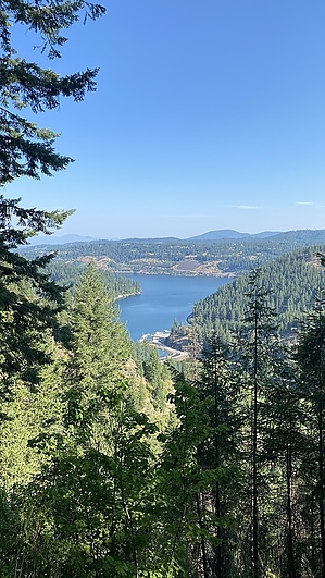
No caribou in the vicinity by LindaAnn Hike: The trail heads out from the west end of the Beauty Creek Campground and is signed. You will immediately cross Beauty Creek and head uphill. The trail starts as a series of very long switchbacks, and it initially climbs steeply uphill. Footing is generally good, but there are some narrow spots with slanting rocks on a steep hillside. It's not too difficult heading uphill, but if you come back downhill the same way, you will want to pay attention to your foot placement.
After a while, you will reach another series of shorter switchbacks as you quickly climb 500' to gain Caribou Ridge. At the top of the switchbacks, another trail joins in from the left--pay attention to this junction, so you head in the right direction when heading back downhill. After the junction, the trail somewhat levels off again as you continue to head up towards the summit of Mt Coeur d'Alene, which is ahead of you but mostly hidden in the trees. Eventually, you will reach a forest road and a small picnic area. Cross the road, and the trail continues on the other side and is marked. You're getting pretty close to the summit now, so don't give up yet. The trail will head west, getting a little steeper again, then will turn to the southeast for the final stretch to the summit. Shortly before the top, yet another trail joins in from the right but continue heading straight and uphill. Just shy of the summit, the trail reaches an old forest road. There will be a large campsite to your right but continue up the road a short distance to the summit. There used to be a lookout tower up top, but that seems to be long gone. There is a metal structure (cabin?) at the end of the road, but I wouldn't step inside it. Unfortunately, there are no views due to the dense trees, but there are some concrete blocks on both sides of the road to sit on and relax before heading back down. Check out the Official Route and Triplogs. Leave No Trace and +Add a Triplog after your hike to support this local community. One-Way Notice This hike is listed as One-Way. When hiking several trails on a single "hike", log it with a generic name that describes the hike. Then link the trails traveled, check out the example. | |||||||||||||||||||||||||||||||||||||||||||||||||||||||||||||||||||||||||||||||||||||||||


