Most hikes on trails in the Capitol Reef National Park are not that long or difficult. This is one of the more challenging, but it should be pretty easy for most people who hike frequently. Stats are from the NPS.
The hike leaves from the parking lot on the south side of the scenic road in Fruita, and across from the nature center. It ascends a graded dirt service road before it leaves on a built trail and starts up the basalt covered mesa. Early on, views are of the orchards, Fruita, and the campground, as well as the canyons around the Fruita area.
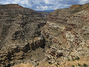
The trail crosses the mesa over slightly rolling terrain with expansive views of the surrounding country. You lose some elevation when crossing from basalt rock to red Moenkopi(?) formation rock and then begin to climb somewhat steeply towards the overlook. The rest of the hike is in open pinyon-juniper woodland and ascends the slope to the overlook. A large rock pile marks the end of the trail and the overlook, and a short social path takes you to some better views near the gorge. Return the way you came.
Views are of the Fremont River Gorge, the rock around this area of the park and distant mountains including the Henry Mountains.
WARNING! Hiking and outdoor related sports can be dangerous. Be responsible and prepare for the trip. Study the area you are entering and plan accordingly. Dress for the current and unexpected weather changes. Take plenty of water. Never go alone. Make an itinerary with your plan(s), route(s), destination(s) and expected return time. Give your itinerary to trusted family and/or friends.
Permit $$
NPS
Capitol Reef National Park $$ per Vehicle, good for Seven Days - View Information
Directions
Road
Paved - Car Okay
To hike Enter Capitol Reef National Park and proceed south on the scenic drive to the Ripple Rock Nature Center. Park in one of the lots near it, and locate the dirt service road on the slope to the south. The road is the trailhead, and there is a sign here for the trail.
page created by joebartels on Jul 22 2018 11:12 am
 Route Editor