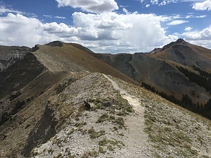
The Horsethief Trail #215 begins at the end of Forest Service Road #871 and ends at the Forest boundary where it crosses onto BLM and continues on for approximately 3 more mile following an old jeep road until it ends at Engineer Pass. The trail ascends gradually along a beautiful forested mountainside and enters an alpine area behind the Amphitheater. As the trail continues to climb it opens up to spectacular views. The distance from the trail beginning to the Bridge of Heaven is approximately 4.2 miles at an elevation of 12,368 feet. The altitude gain along this trail is approximately 3,500 feet before crossing onto the BLM and the American Flats. Approximately 3 miles of the trail travels through the Uncompahgre Wilderness where Wilderness Regulations apply.
When hiking several trails on a single "hike", log it with a generic name that describes the hike. Then link the trails traveled, check out the example.
WARNING! Hiking and outdoor related sports can be dangerous. Be responsible and prepare for the trip. Study the area you are entering and plan accordingly. Dress for the current and unexpected weather changes. Take plenty of water. Never go alone. Make an itinerary with your plan(s), route(s), destination(s) and expected return time. Give your itinerary to trusted family and/or friends.
Permit $$
no fees or permits reported
if incorrect tell us about it
Directions
Road
To hike From Ouray, travel north on Hwy 550 for approximately 2 miles to the intersection with County Road 14. Turn right onto CR 14 and continue for approximately 3.5 miles, CR 14 turns into Forest Service Road 871. The trail access is approximately 1 mile past the Dexter Creek Trail Access. 4WD is recommended to cross Dexter Creek, or park and hike from the Dexter Trail Access. Parking is on the left side of the road near the Wedge Mine rock piles. The trail begins about 100 yards on the right.
 Route Editor


